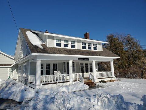
710 Rte 28 Harwich Port, MA 02646-1931
Property profile & analytics
710 Rte 28, Harwich Port, MA 02646-1931
- Medical Office Space
- 33,302 SF
- 1.92 lot acres
Property ID
US38-1753750
The Realmo ID is a unique identifier assigned to every property, incorporating country codes and precise geo-coordinates for 300x300-foot land blocks. It enables standardized data collection and seamless integration of disparate sources such as ownership, tax, title data and physical specifications. By aggregating current and historical records, the Realmo ID powers advanced analytics and delivers deep, verifiable insights for real estate professionals.
Location Intelligence
Current Use by Public Records
- Medical Office Space
Property Details for 710 Rte 28
- Year built
- 1989
- Construction
- FRAME
- Lot size
- 1.92 lot acres
- Zone code
- R
- Property type
- Medical Office Space
- Property subtype
- Medical centers
- APN
- HARW M:15 P:K2
- APU
- HARWM15PK2
Sales History
| Date | Price | Buyer | Seller | Deed Type | Mortgage |
|---|---|---|---|---|---|
| May 6, 2009 | — | Building Down Road LLC | — | Deed Of Trust · related | $1.8M · United Bank |
| Oct 15, 2008 | $2,250,000 | Building Down Road LLC | Sa Fennell RT Hp | Grant Deed | — |
| — | — | Outer Cape Health Svcs | — | Deed Of Trust · related | $500k · Mass Dev Hefa T |
Value Estimations
based on Realmo’s proprietary methodology
-
AI approach
- Method
- Estimation
- ML approach
- $960,000
-
Comparable approach
- Method
- Estimation
- AI Estimate
- $2,175,000
Market price range: $1.34M - $4.93M
Get a detailed, property-specific estimation — fast and free
Location Insight
- Map
- Local Demand
- City
- Harwich Port
- County
- Barnstable
- State
- Massachusetts
- Longitude
- -70.0606
- Latitude
- 41.6705
- CBSA code
- 12700
- CBSA name
- BARNSTABLE TOWN, MA METROPOLITAN STATISTICAL AREA
Property Tax & Assessments
Tax date
Tax Amount
Assessed Land Value
Assessed Improvement Value
Total Assessed Value
Applied Tax Rate
Land Market Value
Improvement Market Value
Total Market Value
2024
$28,996
$532,700
$4,275,900
$4,808,600
-
$0.00
$0.00
$0.00