Entity Owned
Ownership intelligence
Owner of record from public deeds, plus portfolio, hold profile and investor signals where the data supports them. Included with a plan.
Owner contacts
Skip-traced phones and e-mails of the owner. Included with a plan.
Debts
Recorded lenders, amounts and estimated maturities of the owner's loan book — included with a plan.
Property tax · 2019
Value estimate
· Nov 2026Realmo valuation models over county records and 5 qualifying comparable sales.
Recently sold
Cap rate analysis
No income signal is modeled for this parcel yet — the Cap Rates tab runs the workflow.
Zoning insight
Location intelligence
Demand index: how under-served this business type is around this point — modeled from the LocInt grid (area demand vs. what already operates, adjusted by real visit traffic). Higher means stronger unmet demand.
Location
Every figure names its source: public record, benchmark, or modeled. Coverage varies by property — thin data is stated as missing, never invented.
Comparables
6 recorded sales · 17 properties nearbyComparable nearby


Similar Nearby for Sale


Similar Nearby for Lease


Instant AI valuation built from comps, income signals, and proprietary benchmarks.A defensible range, not a single guess.
from $199/month
- GBA
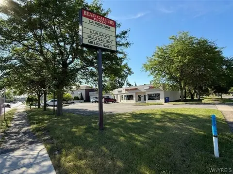
- 6,837 SF
- Lot area
- 2.28 ac
- Year built
- 1985
- Stories
- 1
- APN
- 142289 54.04-1-3.11
- Zoning
- CTR-5
- Assessed value · 2023
- $847,000
- Annual tax · 2019
- $43,733
- Restaurant · current use
- Office Building
Cap rate calculated from real income and expense signals, benchmarked against sales of similar assets nearby.
from $199/month
Price sensitivity
The rate is the decision lever; valuation is the consequence.
The recorded zoning designation, what the district officially allows, and the municipal source it comes from.
Zoning designation
Registration is required before the official district profile is shown.
Official district profile
The Center 5 District is intended to create new walkable mixed-use places with human-scaled internal streets. The district standards are intended to create a network of continuous high-quality active and walkable streets…
Unlock the evidence behind ownership: portfolio, transactions, debt and any signals we can model, to help you decide who to contact next.
Registration is required before any owner information is shown.
Phones and e-mails of the people behind this property's owner, traced from licensed contact data.
Owner phones and e-mails come with a plan - traced from licensed contact data, with verification and Do-Not-Call flags on every number.
The mortgage data comes with a plan: recorded loans of the owner - lender, amount, rate and the estimated maturity - as part of the Ownership Intelligence workspace.
Registration is required before any owner information is shown.
Rey answers here. ChatGPT, Grok and Claude get the same data packet.
Includes: Price & PSF · Cap rate · Location · Zoning
Our comps and market reports get this label in your Google results.
 One click on Google
- 10 Targeted Leads
- 1 Full Property Report
- Lead Lists by Intent
- Signals & Scores
- Building Details
- Value Estimation
- Cap Rate Evaluation
- Liens & Mortgages
- Ownership & Contacts
- Local Market trends
-
Zoning Insight— not in this plan -
Location Analytics— not in this plan
- 300 Targeted Leads a month
- 30 Full Property Reports
- Lead Lists by Intent
- Signals & Scores
- Building Details
- Value Estimation
- Cap Rate Evaluation
- Liens & Mortgages
- Ownership & Contacts
- Local Market trends
- Zoning Insight
-
Location Analytics— not in this plan
- 1,500 Targeted Leads a month
- 150 Full Property Reports
- Lead Lists by Intent
- Signals & Scores
- Building Details
- Value Estimation
- Cap Rate Evaluation
- Liens & Mortgages
- Ownership & Contacts
- Local Market trends
- Zoning Insight
- Location Analytics
The PDF can’t be displayed here
Use Download PDF or Open in new tab above to view the sample report.
Sample leads
-
 Off Market
250 NE 34TH ST, MIAMI, FL 33137-3812
Held 8 yrs
250 NE 34TH ST, MIAMI, FL 33137-3812
-
 Off Market
230 W 41ST ST #235, NEW YORK, NY 10036-7207
Held 14 yrs
230 W 41ST ST #235, NEW YORK, NY 10036-7207
-
 Off Market
630 GOVERNOR PRINTZ BLVD, PHILADELPHIA, PA 19113
Absentee
630 GOVERNOR PRINTZ BLVD, PHILADELPHIA, PA 19113
-
 Off Market
3572 N ELSTON AVE, CHICAGO, IL 60618-4318
Held 8 yrs
3572 N ELSTON AVE, CHICAGO, IL 60618-4318
Sample leads
-
 Off Market
22840 WOODWARD AVE, FERNDALE, MI 48220-1735
Loan from 19998.0% rateOakland County Business Financ
22840 WOODWARD AVE, FERNDALE, MI 48220-1735
-
 Off Market
435-437 FRELINGHUYSEN AVE #437, NEWARK, NJ 07114-1426
Loan from 2011Freedom Bank
435-437 FRELINGHUYSEN AVE #437, NEWARK, NJ 07114-1426
-
 Off Market
4340 VIRGINIA BCH BLVD, VIRGINIA BEACH, VA 23452-1238
Loan from 2008Resource Bank
4340 VIRGINIA BCH BLVD, VIRGINIA BEACH, VA 23452-1238
-
 Off Market
5120 25TH AVE NE, SEATTLE, WA 98105-4121
Loan from 20018.7% rateJune H
5120 25TH AVE NE, SEATTLE, WA 98105-4121
Still being built. It lands here next, beside the two above.
The PDF can’t be displayed here
Your browser has no PDF viewer of its own.