00827020 Star Peak Rd Imlay, NV 89418
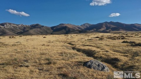
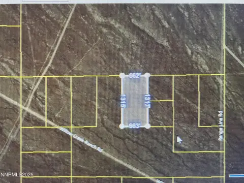
This exceptional 20.77-acre parcel of land presents a unique opportunity in the desirable Imlay, Nevada area. Boasting breathtaking mountain and desert vistas, this property offers a tranquil escape while remaining conveniently close to the towns of Imlay and Mill City. The land is zoned AMR (Agriculture, Mining, Recreation), allowing for a variety of uses, including residential development. Imagine building your dream home amidst this serene landscape, enjoying the expansive views and quietude. The property is easily accessible via existing roads, with convenient access to Interstate 80, providing easy commutes to Winnemucca (approximately 20 minutes west), Reno (approximately 2 hours east), and Salt Lake City (approximately 4 hours west). While off-grid, utilities are relatively accessible; electric lines are located approximately 4500 feet away, and propane delivery is available locally. Water and sewage would typically be handled via private well and septic systems. This property is ideal for camping, off-road recreation, or building a home, offering a blend of rural tranquility and convenient access to amenities and employment opportunities near the Florida Canyon mine and the planned West Coast Salmon facility. A 30-foot easement will be reserved along the east edge for access to the adjacent property. The property is sold as-is, where-is; buyers are responsible for conducting their own due diligence regarding development possibilities and utilities. Pershing County APN: 008-270-20. GPS coordinates: 40.65923, -118.11695.
Cap rate
Implied · in-place · derived from last sale + estimated NOIValue
AI, CAP & Alternative Use estimations · Realmo proprietary blendComparables
6 recent transactions · within 1.5 miComparable in this City


Similar Nearby for Sale


Property description
Physical attributes from public recordsZoning & alternative use
No recorded transactions found for this property.
Costs & Benchmarks
Operating expenses, capex projections, utility benchmarks, and submarket comparables — all in one view.
Risks
Flood, climate, environmental, title, and tenant-concentration risk — surfaced with mitigations and source citations.


