Property profile & analytics
93 E Montauk Hwy Hampton Bays, NY 11946
- Banks
- 2,078 SF
- 2.21 lot acres
For Sale
View listing
$2,995,000
Value Estimations
Cap Rate Potential
Location Intelligence
Property ID
US63-5445774
The Realmo ID is a unique identifier assigned to every property, incorporating country codes and precise geo-coordinates for 300x300-foot land blocks. It enables standardized data collection and seamless integration of disparate sources such as ownership, tax, title data and physical specifications. By aggregating current and historical records, the Realmo ID powers advanced analytics and delivers deep, verifiable insights for real estate professionals.
Current Use by Public Records
- Ultra Roofing & Masonry / Roofing Company / General Contractor
Property Details for 93 E Montauk Hwy
- Year built
- 1993
- Lot size
- 2.21 lot acres
- Property size
- 2,078 SF
- Zone code
- HB
- Property type
- Banks
- APN
- 0900-263.00-01.00-032.004
- APU
- 900263000100032004
Description
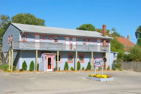
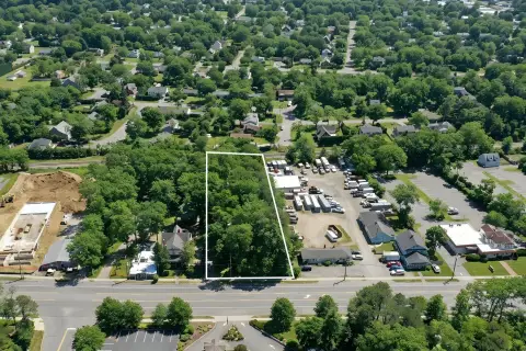
This exceptional 2.2-acre commercial land parcel, located at 93 Montauk Highway in Hampton Bays, New York (zip code 11946), presents a unique investment opportunity. The property boasts 515 feet of highway frontage and is zoned for highway business use. The site includes a 2,700 square foot building with a full basement and a drive-thru. An additional 2,730 square foot building is also present. Importantly, the two parcels comprising this property are severable, offering flexibility for development or subdivision. An approved site plan exists for the existing building, allowing for an expansion of 7,000 square feet of new construction. The total buildable area, including the existing structures and approved expansion, is 96,179 square feet. This property is offered at an asking price of $2,950,000 and presents significant potential for a variety of commercial ventures given its size, location, and existing infrastructure. The property's highway visibility and ample space make it ideal for a range of businesses seeking high traffic exposure in a desirable location. The approved site plan simplifies the development process, reducing potential delays and costs. This is a rare opportunity to acquire a substantial commercial property in a thriving area of Long Island.
Value Estimations
based on Realmo’s proprietary methodology
-
AI approach
-
CAP approach
-
Comparable approach
-
Alternative Use
Get a detailed, property-specific valuation — fast and free
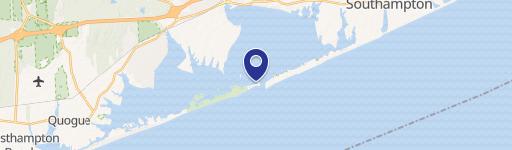
Location Insight
- Map
- Local Demand
- City
- Hampton Bays
- County
- Suffolk
- State
- New York
- Longitude
- -72.519
- Latitude
- 40.8801
- CBSA code
- 35620
- CBSA name
- NEW YORK-NORTHERN NEW JERSEY-LONG ISLAND, NY-NJ-PA METROPOLITAN STATISTICAL AREA
Property Tax & Assessments
Tax date
Tax Amount
Assessed Land Value
Assessed Improvement Value
Total Assessed Value
Applied Tax Rate
Land Market Value
Improvement Market Value
Total Market Value
2020
$8,620
$549,900
$0.00
$549,900
-
$791,223
$0.00
$791,223