Back to Search
Property profile & analytics
OFF-MARKET
Estimated value
$595,000
Banks
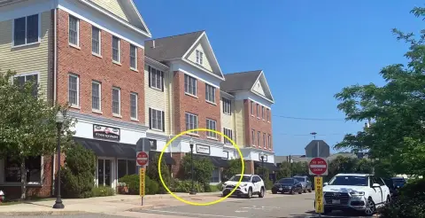
765 Main St Hyannis, MA 02601-4372
Entity Owned
8-yr Hold
~
Est. High Equity
Property ID
US38-1215266
Property profile
Verified
Property type
Banks
Use group
FINANCIAL BUILDING
Year built
1941
Construction
MASONRY/CONCRETE MASONRY UNITS (CMUS)
Total area
6,895 SF
Lot
1.25 ac (54,450 SF)
Zoning code
DV;RB
APN
HYAN M:290 L:098
UPID
US38-1215266
Cap rate & NOI
Priority signal for investors
Implied cap rate, NOI & suggested price
Cap rate vs submarket · NOI estimate · 3 price anchors
Implied cap rate, NOI & suggested price
Cap vs submarket · NOI estimate · 3 price anchors
Value estimations
Realmo proprietary · 4 methods
AI Approach
AI
$565k
CAP Approach
CAP
by Request
Comparable Approach
Comparable
$622k
Blend (final)
Blend
$595k
Owner & transaction history
Rockland T Co · 8 yrs held
Rockland T Co
since 2017
7 recorded transactions
Zoning & alternative use
DV;RB · Hyannis, MA
Permitted uses
Permitted uses
Allowed · conditional · prohibited
Top alternative use upside
Restaurant
$770,000
+16.1%
Medical building
$705,000
+5.9%
Apartment house (5+ units)
$695,000
+4.8%
Cap rate
Implied · in-place · derived from last sale + estimated NOI
Implied Cap rate
#1
Implied · in-place · NOI ÷ last sale
In-place · derived from last sale + estimated NOI
Cap rate, NOI & submarket benchmark
Implied cap rate vs Hyannis submarket · NOI estimate · Typical band, median & reading
Implied cap rate, NOI & submarket benchmark
Cap vs Hyannis submarket · NOI estimate · typical band, median & reading
Refine your cap rate
8-question underwriting flow
1.
Property current status — Going-In vs Stabilized
2.
Price for denominator — asking / offer / market
3.
Leasing status & lease structure (NNN / Gross)
4.
Tenant risk profile & vacancy assumption
5.
Upload T12 / rent roll / OM (optional)
Refine in 60 seconds, get exact suggested price
T12 upload · Submarket benchmarks · Sensitivity grid
Suggested price · 3 cap rate anchors
Income approach @ 5% / 7% / 9% — aggressive / typical / conservative
Suggested price at 5% / 7% / 9% cap
Aggressive / typical / conservative · Implied $/SF per anchor · Sensitivity grid
Suggested price at 5% / 7% / 9% cap
Aggressive / typical / conservative · implied $/SF · sensitivity
Value
AI, CAP & Alternative Use estimations · Realmo proprietary blendValue Estimations
Based on Realmo’s proprietary methodology
AI Approach
Method
Estimation
Statistic approach
by Request
ML approach
$565,000
CAP Approach
CAP Return
Estimation
6%
by Request
6.5%
by Request
7%
by Request
Alternative Use
Use
Estimation
FINANCIAL BUILDING
$665,000
Current use
RESTAURANT
$770,000
Change: +16% · Conversion: Difficult
MEDICAL BUILDING
$705,000
Change: +6% · Conversion: Difficult
APARTMENT HOUSE (5+ UNITS)
$695,000
Change: +5% · Conversion: Difficult
Blend value · Realmo final
$595k
Range $536k – $655k · ±10%
Realmo estimate · informational only.
These numbers are calculated by our models from public records and may not reflect actual market value.
Not an appraisal.
Verify with a licensed appraiser before transacting. Realmo accepts no liability for divergence from real-world outcomes.
View the full estimation — every method, every assumption
Confidence drivers & risk notes · Custom comparable set · Free for first 3 / day
Full estimation methodology
Every method · every assumption · confidence drivers
Price per SF
Sale + rent benchmarks
Subject property
$86 / SF
Submarket sale & rent benchmarks
Median sale $/SF · Asking & closed rent · Submarket vacancy
Submarket sale & rent benchmarks
Median sale $/SF · asking & closed rent · submarket vacancy
Property tax & assessments
Tax year 2024Property tax & assessments
Tax year 2024
Tax billed
$25,275
Tax year 2024
Assessed value
$2,592,300
Assessed 2024
Previous assessed
$2,592,300
+0.0% YoY
Effective rate
0.98%
On assessed value
Assessed land
$352,800
Assessed improvement
$2,239,500
Comparables
6 recent transactions · within 1.5 miComparable in this city
6 recent transactions
Comparable in this City


Similar Nearby for Sale


Similar Nearby for Lease


Recent comparable sales
Sale price & price/SF · Sale date & distance · Adjustments & confidence
Recent comparable sales
Sale price & $/SF · sale date & distance · adjustments
Property description
Physical attributes from public recordsBuilding & lot
Public records
Property type
Banks
Use group
FINANCIAL BUILDING
Status
Off-Market
Year built
1941
Construction
MASONRY/CONCRETE MASONRY UNITS (CMUS)
Heating
HOT WATER
Cooling
YES
Buildings
1
Stories
1
Rooms
1
Bathrooms
4
Total area
6,895 SF
Lot
1.25 ac (54,450 SF)
Zoning code
DV;RB
APN
HYAN M:290 L:098
UPID
US38-1215266
Jurisdiction
BARNSTABLE
Zoning & alternative use
DV;RB · Hyannis, MA
Zoning DV;RB · permitted uses
DV;RB · Hyannis, MA
Permitted & conditional uses
Allowed uses · Special-permit conditions · Prohibited uses
Permitted & conditional uses
Allowed · special-permit conditions · prohibited
Hyannis. Always verify with local authorities before improvements.
Alternative use value scenarios
Repositioning upside vs current use
FINANCIAL BUILDING Current
Est. value
$665,000
RESTAURANT
Est. value
$770,000
MEDICAL BUILDING
Est. value
$705,000
APARTMENT HOUSE (5+ UNITS)
Est. value
$695,000
FINANCIAL BUILDING Current
RESTAURANT
MEDICAL BUILDING
APARTMENT HOUSE (5+ UNITS)
Alternative use deep dive — conversion cost, permits, timeline
Conversion cost estimate · Permit path & risks · Stabilized NOI per option
Alternative use deep dive
Conversion cost · permit path · stabilized NOI per option
Building & site characteristics
From public records
Year built
1941
Construction
MASONRY/CONCRETE MASONRY UNITS (CMUS)
Heating
HOT WATER
Cooling
Yes
Stories
1
Buildings
1
Rooms
1
Bathrooms
4
Lot
1.25 ac
Current owner
From public records · entity-resolved
Rockland T Co
Entity
Mailing address
288 UN ST, ROCKLAND, MA 02370-1803
Ownership since
2017
Owner contacts — direct phone, email, and related entities
Decision-maker phone · Verified email · Related entities & filings
Owner contacts
Email · phone · related entities
Sales History
11 recorded events · public records
Date
Price
Buyer
Seller
Deed Type
Mortgage
Sep 26, 2017
$1,800,000
Rockland T Co
Hyannis Rotary LLC
Quit Claim Deed
—
Nov 2, 2012
$1,620,000
Hyannis Rotary LLC
Shoestring Props LLC
Grant Deed
—
May 15, 2002
—
Shoestring Prop Ltdptn
—
Deed Of Trust
related
$539,000 · Thomas M Sykes
Feb 6, 2002
—
Shoestring Prop Limpar
—
Deed Of Trust
related
$3,000,000 · Thomas M Sykes
Aug 20, 1999
—
Gladstone RT
—
Deed Of Trust
related
$5,000,000 · Thomas M Sykes
Jul 21, 1999
—
Gladstone RT
—
Deed Of Trust
related
$350,000 · Thomas M Sykes
Jan 20, 1999
—
Gladstone RT
—
Deed Of Trust
related
$500,000 · Thomas M Sykes
Aug 4, 1998
—
Gladstone RT
—
Deed Of Trust
related
$800,000 · Thomas M Sykes
Dec 27, 1995
$93,000
G Robert King 2nd
Kom RT
Grant Deed
—
Nov 28, 1995
$412,500
Gladstone RT
Fleet Bk Mass
Grant Deed
—
Apr 27, 1992
$75,000
Gladstone RT
Scott,amethia Bradley
Grant Deed
—
Coming soon
Costs & Benchmarks
Operating expenses, capex projections, utility benchmarks, and submarket comparables — all in one view.
Coming soon
Risks
Flood, climate, environmental, title, and tenant-concentration risk — surfaced with mitigations and source citations.
Try Rey
Ask anything about this address in plain English.
“Is 15.6% cap rate sustainable?” · “Best tenant mix for BU1?” · “What’s the redev upside?”
You own 765 Main St?
List it free. Reach 20,000 daily buyers.
We’ve already pulled the facts. Confirm photos + price and you’re live in 2 minutes.
List this address →
Full reports are paid
Unlock the full Property Analytics report
Start free for 7 days — no card required. Full owner contacts, all 4 valuations with methodology, refine flow, comparable adjustments, foot-traffic deep dive, export to PDF / CSV.


