Back to Search
Property profile & analytics
OFF-MARKET
Grocery and convenience stores
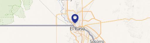
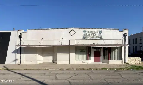
1400 Yandell Dr El Paso, TX 79902-3656
Entity Owned
Free & Clear
Property ID
US82-1240797
Property profile
Verified
Property type
Grocery and convenience stores
Use group
GROCERY, SUPERMARKET
Year built
1976
Total area
2,891 SF
Lot
0.23 ac (10,088 SF)
Zoning code
C2H
APN
M946-999-0100-6500
UPID
US82-1240797
Cap rate & NOI
Priority signal for investors
Implied cap rate, NOI & suggested price
Cap rate vs submarket · NOI estimate · 3 price anchors
Implied cap rate, NOI & suggested price
Cap vs submarket · NOI estimate · 3 price anchors
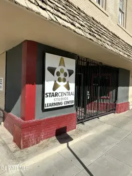
Current use
Occupant on record · Public records
-
Circle K Grocery & Convenience Store
-
Circle K | Gas Station Gas Station
-
Bitcoin Depot ATM Atm
-
UTEP High School
Value estimations
Realmo proprietary · 4 methods
AI Approach
AI
by Request
CAP Approach
CAP
by Request
Comparable Approach
Comparable
by Request
Blend (final)
Blend
by Request
Owner & transaction history
The Crest Ranch LLC
The Crest Ranch LLC
since 2025
3 recorded transactions
Zoning & alternative use
C2H · El Paso, TX
Permitted uses
Permitted uses
Allowed · conditional · prohibited
Cap rate
Implied · in-place · derived from last sale + estimated NOI
Implied Cap rate
#1
Implied · in-place · NOI ÷ last sale
In-place · derived from last sale + estimated NOI
Cap rate, NOI & submarket benchmark
Implied cap rate vs El Paso submarket · NOI estimate · Typical band, median & reading
Implied cap rate, NOI & submarket benchmark
Cap vs El Paso submarket · NOI estimate · typical band, median & reading
Refine your cap rate
8-question underwriting flow
1.
Property current status — Going-In vs Stabilized
2.
Price for denominator — asking / offer / market
3.
Leasing status & lease structure (NNN / Gross)
4.
Tenant risk profile & vacancy assumption
5.
Upload T12 / rent roll / OM (optional)
Refine in 60 seconds, get exact suggested price
T12 upload · Submarket benchmarks · Sensitivity grid
Suggested price · 3 cap rate anchors
Income approach @ 5% / 7% / 9% — aggressive / typical / conservative
Suggested price at 5% / 7% / 9% cap
Aggressive / typical / conservative · Implied $/SF per anchor · Sensitivity grid
Suggested price at 5% / 7% / 9% cap
Aggressive / typical / conservative · implied $/SF · sensitivity
Value
AI, CAP & Alternative Use estimations · Realmo proprietary blendValue Estimations
Based on Realmo’s proprietary methodology
AI Approach
CAP Approach
Comparable Approach
Alternative Use
Get a detailed, property-specific estimation — fast and free
Price per SF
Sale + rent benchmarks
Subject property
—
Submarket sale & rent benchmarks
Median sale $/SF · Asking & closed rent · Submarket vacancy
Submarket sale & rent benchmarks
Median sale $/SF · asking & closed rent · submarket vacancy
Property tax & assessments
Tax year 2023Property tax & assessments
Tax year 2023
Tax billed
$8,330
Tax year 2023
Assessed value
$301,149
Assessed 2023
Previous assessed
$301,149
+0.0% YoY
Effective rate
2.77%
On assessed value
Assessed land
$52,463
Assessed improvement
$248,686
Land market value
$52,463
Improvement market value
$248,686
Total market value
$301,149
Comparables
6 recent transactions · within 1.5 miComparable in this city
6 recent transactions
Comparable in this City

Similar Nearby for Sale


Similar Nearby for Lease


Recent comparable sales
Sale price & price/SF · Sale date & distance · Adjustments & confidence
Recent comparable sales
Sale price & $/SF · sale date & distance · adjustments
Property description
Physical attributes from public recordsBuilding & lot
Public records
Property type
Grocery and convenience stores
Use group
GROCERY, SUPERMARKET
Status
Off-Market
Year built
1976
Heating
FORCED AIR
Cooling
CENTRAL
Stories
1
Total area
2,891 SF
Lot
0.23 ac (10,088 SF)
Zoning code
C2H
APN
M946-999-0100-6500
UPID
US82-1240797
Jurisdiction
EL PASO
Zoning & alternative use
C2H · El Paso, TX
Zoning C2H · permitted uses
C2H · El Paso, TX
Permitted & conditional uses
Allowed uses · Special-permit conditions · Prohibited uses
Permitted & conditional uses
Allowed · special-permit conditions · prohibited
El Paso. Always verify with local authorities before improvements.
Building & site characteristics
From public records
Year built
1976
Heating
FORCED AIR
Cooling
Yes
Stories
1
Lot
0.23 ac
Current owner
From public records · entity-resolved
The Crest Ranch LLC
Entity
Free & Clear · 0 yrs held
Mailing address
PO BOX 1119, DRIPPING SPRINGS, TX 78620-1119
Ownership since
2025
Owner contacts — direct phone, email, and related entities
Decision-maker phone · Verified email · Related entities & filings
Owner contacts
Email · phone · related entities
Sales History
3 recorded events · public records
Date
Price
Buyer
Seller
Deed Type
Mortgage
Jul 29, 2025
—
The Crest Ranch LLC
Prestigio Properties Viii LLC
Special Warranty Deed
—
Jul 1, 2021
—
Prestigio Properties Viii LLC
Richard Castro
Special Warranty Deed
—
Aug 31, 2020
—
Richard Castro
Haddad Building Ptshp
Warranty Deed
related
—
Coming soon
Costs & Benchmarks
Operating expenses, capex projections, utility benchmarks, and submarket comparables — all in one view.
Coming soon
Risks
Flood, climate, environmental, title, and tenant-concentration risk — surfaced with mitigations and source citations.
Try Rey
Ask anything about this address in plain English.
“Is 15.6% cap rate sustainable?” · “Best tenant mix for BU1?” · “What’s the redev upside?”
You own 1400 Yandell Dr?
List it free. Reach 20,000 daily buyers.
We’ve already pulled the facts. Confirm photos + price and you’re live in 2 minutes.
List this address →
Full reports are paid
Unlock the full Property Analytics report
Start free for 7 days — no card required. Full owner contacts, all 4 valuations with methodology, refine flow, comparable adjustments, foot-traffic deep dive, export to PDF / CSV.


