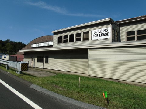
125 Garder Rd Monroe, CT 06468-1240
Property profile & analytics
125 Garder Rd, Monroe, CT 06468-1240
- Industrial land
- 9.40 lot acres
Property ID
US15-0520192
The Realmo ID is a unique identifier assigned to every property, incorporating country codes and precise geo-coordinates for 300x300-foot land blocks. It enables standardized data collection and seamless integration of disparate sources such as ownership, tax, title data and physical specifications. By aggregating current and historical records, the Realmo ID powers advanced analytics and delivers deep, verifiable insights for real estate professionals.
Location Intelligence
Current Use by Public Records
- Industrial land
Property Details for 125 Garder Rd
- Lot size
- 9.40 lot acres
- Zone code
- I2
- Property type
- Industrial land
- APN
- MONR M:095 B:002 L:00
- APU
- MONRM095B002L00
Sales History
| Date | Price | Buyer | Seller | Deed Type | Mortgage |
|---|---|---|---|---|---|
| Mar 30, 2020 | $160,000 | 125 Garder Road LLC | Joseph Marek | Warranty Deed | — |
| Feb 11, 2003 | $170,000 | Generation 2nd Bldrs LLC | Shaw,travis | Warranty Deed | $250k · Hudson United Bank |
| Nov 13, 2001 | $251,000 | Todd Cascella | Mattegat,myrtle O | Warranty Deed | — |
Value Estimations
based on Realmo’s proprietary methodology
-
AI approach
-
CAP approach
-
Comparable approach
-
Alternative Use
Get a detailed, property-specific estimation — fast and free
Location Insight
- Map
- Local Demand
- City
- Monroe
- County
- Fairfield
- State
- Connecticut
- Longitude
- -73.2412
- Latitude
- 41.3475
- CBSA code
- 14860
- CBSA name
- BRIDGEPORT-STAMFORD-NORWALK, CT METROPOLITAN STATISTICAL AREA
Property Tax & Assessments
Tax date
Tax Amount
Assessed Land Value
Assessed Improvement Value
Total Assessed Value
Applied Tax Rate
Land Market Value
Improvement Market Value
Total Market Value
2023
$8,216
$218,800
$0.00
$218,800
-
$0.00
$0.00
$0.00