Agricultural Land with Interstate
S State Road 109 Knightstown, IN 46148
For Sale
$1,125,000
LAND - Knightstown, IN
Lot Size25.00 Acres
Days on Market254
Property Features for S State Road 109
General Information
- Property type
- Land
- Property subtype
- Other
- Zoning
- Agricultural
- Fencing
- Chain Link
- Standard status
- Active
- APN
- 331608000305000029
- Lot size
- 25.00 Acres
Taxes and HOA fees
- Tax Year
- 2024
- Tax Description
- Pt Sw1/4 8-16-9 12A & 4.50A (Total 16.50A)
Utilities
- Sewer type
- Septic Needed
Listing Agency:
Highgarden Real Estate
(317) 205-4320
Listed By:
Albert Stancato · License #RB16000255
(317) 280-4663
Added: Nov 14, 2025
Changed: Jun 16
Last Checked: Jul 26 at 12:06PM
MLS# 22073584
Copyright © 2026 MIBOR Service Corporation. All rights reserved. All information provided by the listing agent/broker is deemed reliable but is not guaranteed and should be independently verified.
Investment Insights
Based on property information with market context.
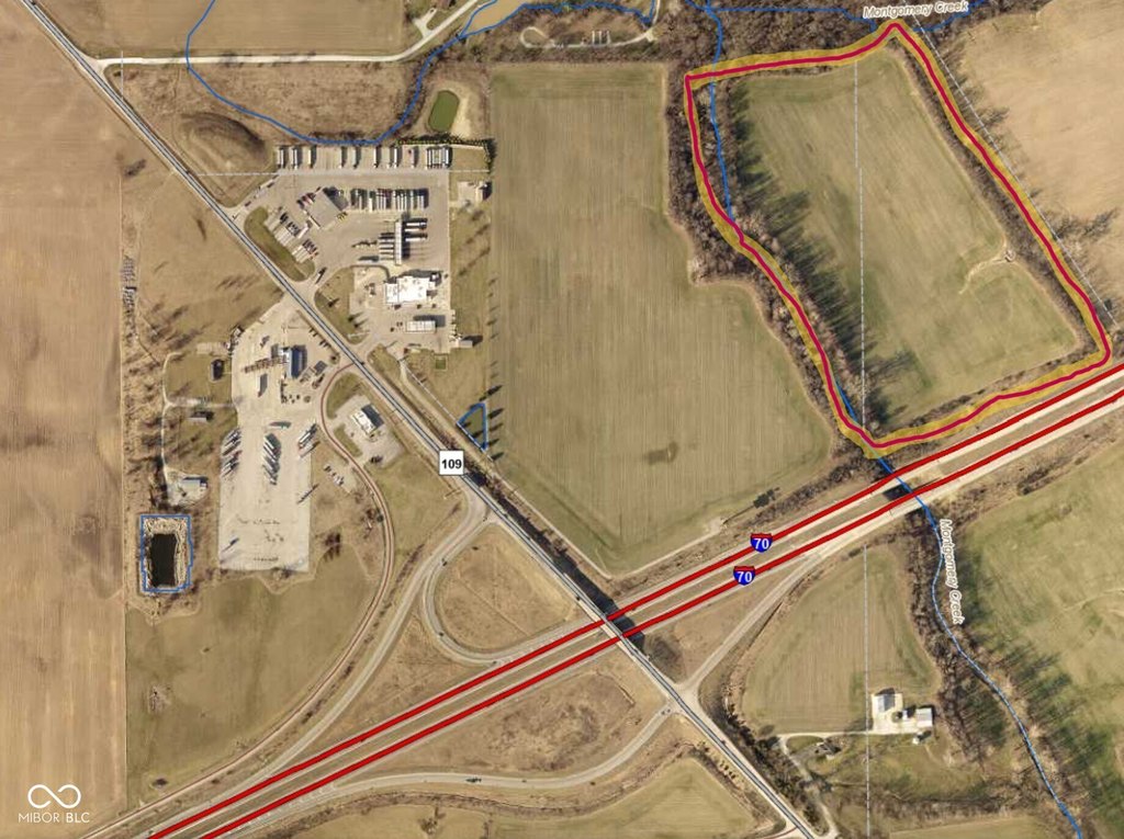
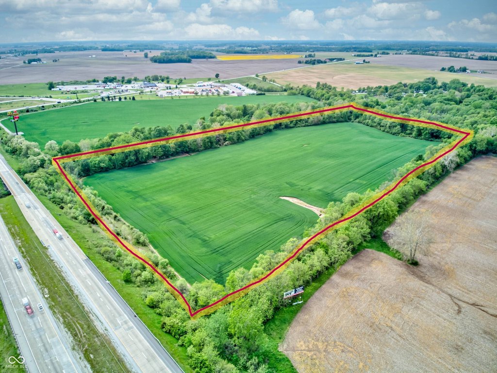
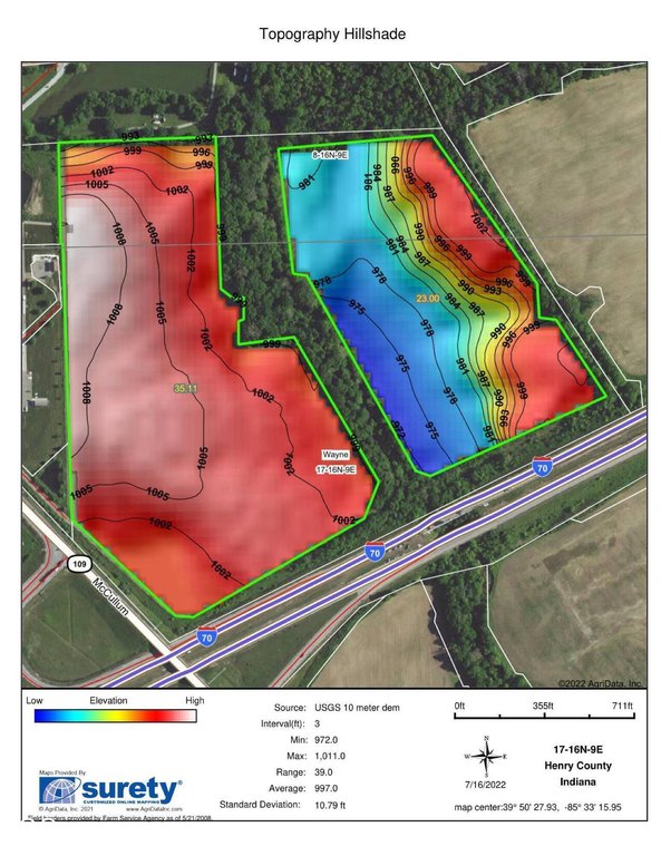
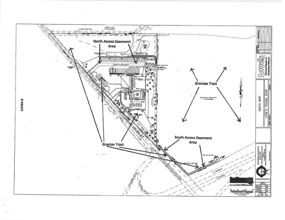
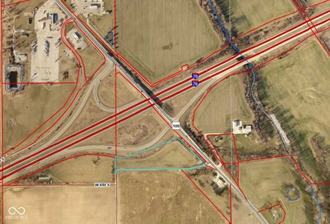
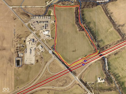
This offering consists of approximately 25 acres of open farmland zoned Agricultural in Knightstown, Indiana. A portion of the tract lies near the floodway and partially within a flood zone, which may affect suitability for certain improvements while aligning with lower-impact concepts. The seller notes higher-elevation areas within the property that could provide additional placement options depending on the buyer’s intended development. Two recorded easements are set as deed restrictions on the Loves Travel Center and provide dedicated access from State Road 109.
The land is positioned directly behind the Loves Travel Stop and just off the Interstate 70 Knightstown exit (Exit 115). The tract is described as part of a larger property group owned by the seller, though only this specific lot is being offered for sale. The seller indicates utilities will require installation of a septic system and well if desired. The seller is also willing to subdivide for multiple buyers. Buyers should confirm tax information, as taxes are noted as not accurate.
For tenants, buyers, or developers seeking flexible site options, the mix of agricultural zoning, deed-restricted access from State Road 109, and on-site floodway/flood zone considerations can support a range of low-impact uses. Because the property’s zoning is Agricultural and utilities are not currently installed on the site, interested parties should conduct their own due diligence on development feasibility, permitting requirements, and any conversion pathway.
Key Highlights
- About 25 acres of open farmland behind the Loves Travel Stop, just off I‑70 at Exit 115 (Knightstown, IN)
- Agricultural zoning with stated flexibility for uses such as solar farms, trailer storage, outdoor recreation, camping, and other low‑impact concepts
- Portions near the floodway and partially within a flood zone
Property Analytics
Property Profile
Location Intelligence
Current Use by Public Records
Alt. Energy / Solar ...


FAQs
What type of property is this?
Agricultural land / Farmland - Zoned agricultural farmland with deed-restricted easements off State Road 109, offering flexible low-impact development options.
Where is this agricultural land / farmland located?
The property is located at S State Road 109 Knightstown, IN.
What is the asking price?
The asking price for this property is $1,125,000.
What are key features of this property?
This property features: About 25 acres of open farmland behind the Loves Travel Stop, just off I‑70 at Exit 115 (Knightstown, IN); Agricultural zoning with stated flexibility for uses such as solar farms, trailer storage, outdoor recreation, camping, and other low‑impact concepts; Portions near the floodway and partially within a flood zone