Waterfront Lakefront
Lake Edge Trail lot 56 Wisconsin Rapids, WI 54494
For Sale
$59,000
LAND - Wisconsin Rapids, WI
Lot Size0.43 Acres
Days on Market283
Property Features for Lake Edge Trail lot 56
General Information
Property type
Land
Property subtype
Other
Zoning
Res/PUD
Standard status
Active
APN
1801803
Lot size
0.43 Acres
Taxes and HOA fees
Tax Year
2024
Tax Description
S6 T21 R6E UNIT 56, POINT COVE CONDOMINI
Tax Annual Amount
580
Utilities
Sewer type
None
Water source
Well Needed, None
Water front features
Waterfront, Lake
Water front
1
Listing Agency:
WisconsinLakefront.com, LLC
(608) 228-8888
Listed By:
Brad Pavloski · License #5334890
(608) 228-8888
Added: Oct 21, 2025
Changed: Jul 28
Last Checked: Jul 30 at 6:06AM
MLS# 2011102
Copyright © 2026 REALTORS® Association of South Central Wisconsin. All rights reserved. All information provided by the listing agent/broker is deemed reliable but is not guaranteed and should be independently verified.
Investment Insights
Based on property information with market context.
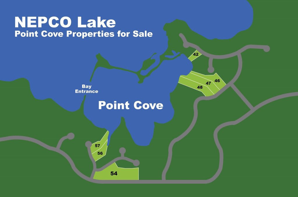
This offering is a waterfront land lot described as Lot 56 at Point Cove on NEPCO Lake. The property is set with a heavily wooded, old-growth forest feel and includes sand-bottom shoreline characteristics along the lake edge. The lot size is listed as 0.43 acres, and the transaction is for sale.
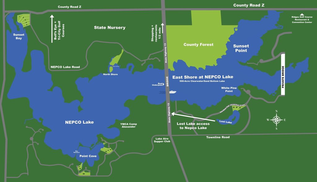
The site is positioned on NEPCO Lake, which is described in the remarks as a 500-acre hard sand bottom watersport lake. The property is also described as being situated between two championship golf courses and the Wisconsin River. The remarks further state that the owner can have shoreline access without a conservancy strip.
Zoning is provided as Res/PUD, which may support residential or planned unit development uses, subject to applicable approvals. For buyers seeking a lakeside property with direct shoreline ownership and a wooded setting, this lot provides a defined, waterfront building site opportunity near the recreation-focused features described in the listing. Buyers should verify the feasibility of their intended plans with the local permitting authority under the Res/PUD zoning designation.
Key Highlights
- Waterfront lot on NEPCO Lake with Waterfront and Lake features
- 500‑acre NEPCO Lake with hard sand bottom and clear water
- Heavily wooded old growth forest setting on the lot
Property Analytics
Property Profile
Location Intelligence
Current Use


Frequently Asked Questions
What type of property is this?
Waterfront Land - Wooded waterfront lot on NEPCO Lake with direct shoreline ownership for recreation or a future home site.
Where is this waterfront land located?
The property is located at Lake Edge Trail lot 56 Wisconsin Rapids, WI.
What is the asking price?
The asking price for this property is $59,000.
What are key features of this property?
This property features: Waterfront lot on NEPCO Lake with Waterfront and Lake features; 500‑acre NEPCO Lake with hard sand bottom and clear water; Heavily wooded old growth forest setting on the lot