Waterfront Lake
Cove Trail lot 46 Wisconsin Rapids, WI 54494
For Sale
$49,000
LAND - Wisconsin Rapids, WI
Lot Size0.58 Acres
Days on Market283
Property Features for Cove Trail lot 46
General Information
Property type
Land
Property subtype
Other
Zoning
Res/PUD
Standard status
Active
APN
1801793
Lot size
0.58 Acres
Taxes and HOA fees
Tax Year
2024
Tax Description
S6 T21 R6E UNIT 46, POINT COVE CONDOMINI
Tax Annual Amount
632
Utilities
Sewer type
None
Water source
Well Needed, None
Water front features
Waterfront, Lake
Water front
1
Listing Agency:
WisconsinLakefront.com, LLC
(608) 228-8888
Listed By:
Brad Pavloski · License #5334890
(608) 228-8888
Added: Oct 21, 2025
Changed: Jul 28
Last Checked: Jul 30 at 6:06AM
MLS# 2011098
Copyright © 2026 REALTORS® Association of South Central Wisconsin. All rights reserved. All information provided by the listing agent/broker is deemed reliable but is not guaranteed and should be independently verified.
Investment Insights
Based on property information with market context.
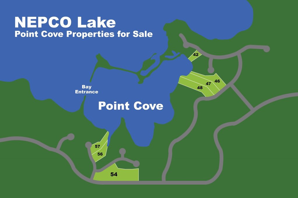
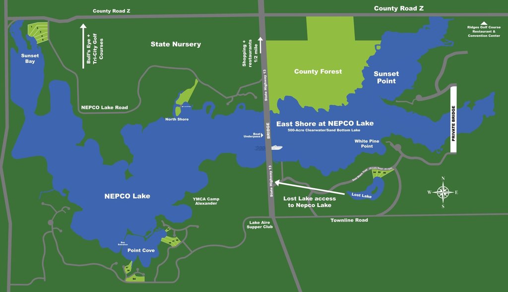
This offering is Lot 46 in Point Cove, a waterfront land parcel on NEPCO Lake. The property totals 0.58 acres and is described as heavily wooded, with an old-growth forest feel. The lakefront includes a sand bottom along the shoreline, providing direct adjacency to NEPCO Lake water. Public remarks also note that the lot allows for ownership of its shoreline, with no conservancy strip.
NEPCO Lake is identified as a 500-acre body of water with a hard sand bottom. The lot is positioned between two championship golf courses and the Wisconsin River, placing it within a broader recreational and waterfront setting in Central Wisconsin. The parcel is located at Cove Trail, Lot 46, in Wisconsin Rapids, Wood County, Wisconsin.
For buyers looking to own lake frontage in a residential/PUD zoning environment, this parcel offers a natural, wooded waterfront setting with sand shoreline access. It may suit buyers interested in building a single-family residence or a planned residential use consistent with Res/PUD zoning, based on their own design and site-development requirements. Buyers should confirm all zoning, permitting, and site conditions directly with the appropriate local authorities.
Key Highlights
- Waterfront lot on NEPCO Lake with lake frontage and a shoreline setting
- NEPCO Lake is a 500‑acre watersport lake with a hard sand bottom
- Heavily wooded old growth forest setting on the property
Property Analytics
Property Profile
Location Intelligence
Current Use


Frequently Asked Questions
What type of property is this?
Waterfront Land - Build-ready waterfront lot on NEPCO Lake with heavily wooded surroundings and shoreline sand bottom.
Where is this waterfront land located?
The property is located at Cove Trail lot 46 Wisconsin Rapids, WI.
What is the asking price?
The asking price for this property is $49,000.
What are key features of this property?
This property features: Waterfront lot on NEPCO Lake with lake frontage and a shoreline setting; NEPCO Lake is a 500‑acre watersport lake with a hard sand bottom; Heavily wooded old growth forest setting on the property