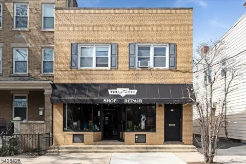
673 Ridgewood Rd Millburn, NJ 07041-1918
Property profile & analytics
673 Ridgewood Rd, Millburn, NJ 07041-1918
- Commercial real estate
- 686 SF
- 0.06 lot acres
Property ID
US59-1935846
The Realmo ID is a unique identifier assigned to every property, incorporating country codes and precise geo-coordinates for 300x300-foot land blocks. It enables standardized data collection and seamless integration of disparate sources such as ownership, tax, title data and physical specifications. By aggregating current and historical records, the Realmo ID powers advanced analytics and delivers deep, verifiable insights for real estate professionals.
Location Intelligence
Current Use by Public Records
- Commercial real estate
Property Details for 673 Ridgewood Rd
- Year built
- 1925
- Construction
- TYPE NOT SPECIFIED
- Lot size
- 0.06 lot acres
- Property type
- Commercial real estate
- APN
- 12 00213-0000-00008
- APU
- 1200213000000008
Sales History
| Date | Price | Buyer | Seller | Deed Type | Mortgage |
|---|---|---|---|---|---|
| Feb 24, 2025 | $438,000 | Sonia Pap | Donald Werner | Deed | — |
| Dec 21, 2017 | $286,000 | Donald Werner | Bwscw Properties LLC | Grant Deed | — |
| Nov 14, 2011 | $275,000 | Bwscw Properties LLC | Danzi,christine A | Grant Deed | $220k · Lakeland Bank |
Value Estimations
based on Realmo’s proprietary methodology
-
AI approach
-
CAP approach
-
Comparable approach
-
Alternative Use
Get a detailed, property-specific estimation — fast and free
Location Insight
- Map
- Local Demand
- City
- Millburn
- County
- Essex
- State
- New Jersey
- Longitude
- -74.2873
- Latitude
- 40.7267
- CBSA code
- 35620
- CBSA name
- NEW YORK-NORTHERN NEW JERSEY-LONG ISLAND, NY-NJ-PA METROPOLITAN STATISTICAL AREA
Property Tax & Assessments
Tax date
Tax Amount
Assessed Land Value
Assessed Improvement Value
Total Assessed Value
Applied Tax Rate
Land Market Value
Improvement Market Value
Total Market Value
2022
$5,557
$234,200
$51,800
$286,000
-
$234,200
$51,800
$286,000