672 Bog Rd New Portland, ME 04961
Property profile & analytics
672 Bog Rd, New Portland, ME 04961
- Banks
- 950 SF
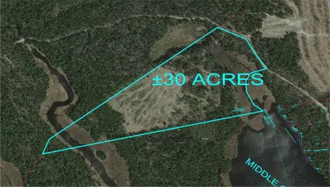
- 30.20 lot acres
Property ID
US42-0400888
The Realmo ID is a unique identifier assigned to every property, incorporating country codes and precise geo-coordinates for 300x300-foot land blocks. It enables standardized data collection and seamless integration of disparate sources such as ownership, tax, title data and physical specifications. By aggregating current and historical records, the Realmo ID powers advanced analytics and delivers deep, verifiable insights for real estate professionals.
Location Intelligence
Current Use by Public Records
- Banks
Property Details for 672 Bog Rd
- Year built
- 1990
- Lot size
- 30.20 lot acres
- Property type
- Banks
- APN
- MPRD M:005 L:023
- APU
- MPRDM005L023
Sales History
| Date | Price | Buyer | Seller | Deed Type | Mortgage |
|---|---|---|---|---|---|
| Apr 30, 2007 | — | Earl A Belanger | — | Deed Of Trust · related | $60k · Rainbow FCU |
| Sep 12, 2005 | — | Earl A Belanger | — | Deed Of Trust · related | $15k · American General Fin |
Value Estimations
based on Realmo’s proprietary methodology
-
AI approach
-
CAP approach
-
Comparable approach
-
Alternative Use
Get a detailed, property-specific estimation — fast and free
Location Insight
- Map
- Local Demand
- City
- New Portland
- County
- Somerset
- State
- Maine
- Longitude
- -70.0732
- Latitude
- 44.9427
Property Tax & Assessments
Tax date
Tax Amount
Assessed Land Value
Assessed Improvement Value
Total Assessed Value
Applied Tax Rate
Land Market Value
Improvement Market Value
Total Market Value
2023
$1,376
$55,600
$44,100
$99,700
-
$0.00
$0.00
$0.00