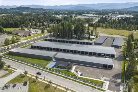
47 Browns Rd Sandpoint, ID 83864-8168
Property profile & analytics
47 Browns Rd, Sandpoint, ID 83864-8168
- Industrial properties
- 900 SF
- 81.57 lot acres
Property ID
US27-1021776
The Realmo ID is a unique identifier assigned to every property, incorporating country codes and precise geo-coordinates for 300x300-foot land blocks. It enables standardized data collection and seamless integration of disparate sources such as ownership, tax, title data and physical specifications. By aggregating current and historical records, the Realmo ID powers advanced analytics and delivers deep, verifiable insights for real estate professionals.
Location Intelligence
Current Use by Public Records
- Industrial properties
Property Details for 47 Browns Rd
- Year built
- 1990
- Lot size
- 81.57 lot acres
- Property type
- Industrial properties
- APN
- RP58N02W010403A
- APU
- RP58N02W010403A
Sales History
| Date | Price | Buyer | Seller | Deed Type | Mortgage |
|---|---|---|---|---|---|
| Jul 13, 2017 | — | Colburn Industrial Park LLC | Terrence Deis JR | Quit Claim Deed · related | — |
Value Estimations
based on Realmo’s proprietary methodology
-
AI approach
-
CAP approach
-
Comparable approach
-
Alternative Use
Get a detailed, property-specific estimation — fast and free
Location Insight
- Map
- Local Demand
- City
- Sandpoint
- County
- Bonner
- State
- Idaho
- Longitude
- -116.53
- Latitude
- 48.4087
- CBSA code
- 41760
- CBSA name
- SANDPOINT, ID MICROPOLITAN STATISTICAL AREA
Property Tax & Assessments
Tax date
Tax Amount
Assessed Land Value
Assessed Improvement Value
Total Assessed Value
Applied Tax Rate
Land Market Value
Improvement Market Value
Total Market Value
2024
$3,420
$774,000
$93,082
$867,082
-
$774,000
$93,082
$867,082