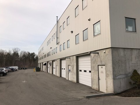
395th Main St Rowley, MA 01969-1207
Property profile & analytics
395th Main St, Rowley, MA 01969-1207
- Industrial properties
- 17,910 SF
- 1.72 lot acres
Property ID
US38-0608908
The Realmo ID is a unique identifier assigned to every property, incorporating country codes and precise geo-coordinates for 300x300-foot land blocks. It enables standardized data collection and seamless integration of disparate sources such as ownership, tax, title data and physical specifications. By aggregating current and historical records, the Realmo ID powers advanced analytics and delivers deep, verifiable insights for real estate professionals.
Location Intelligence
Current Use by Public Records
- Industrial properties
Property Details for 395th Main St
- Year built
- 1982
- Construction
- STEEL FRAME
- Lot size
- 1.72 lot acres
- Property type
- Industrial properties
- APN
- ROWL M:0027 B:0053 L:0002A
- APU
- ROWLM0027B0053L0002A
Sales History
| Date | Price | Buyer | Seller | Deed Type | Mortgage |
|---|---|---|---|---|---|
| Sep 27, 2005 | — | Didax INC | — | Deed Of Trust · related | $400k · Salem Five Cents Savings Bank |
| Dec 31, 1997 | — | Didax INC | — | Deed Of Trust · related | $600k · Salem Five Cents Savings Bank |
| Feb 24, 1993 | — | Didax INC | — | Deed Of Trust · related | $500k · Shawmut Bank Of Boston |
| May 29, 1992 | $600,000 | Mass Bussiness Dev Co | Kent Industrial RT | Grant Deed | — |
Value Estimations
based on Realmo’s proprietary methodology
-
Comparable approach
- Method
- Estimation
- Statistic Estimate
- $1,966,000
- AI Estimate
- $1,152,000
Market price range: $1.80M - $4.54MMarket price range: $560k - $2.97M -
Alternative Use
- Use
- Estimation
- WAREHOUSE, STORAGE
- $2,520,000
Get a detailed, property-specific estimation — fast and free
Location Insight
- Map
- Local Demand
- City
- Rowley
- County
- Essex
- State
- Massachusetts
- Longitude
- -70.8633
- Latitude
- 42.7276
- CBSA code
- 14460
- CBSA name
- BOSTON-CAMBRIDGE-QUINCY, MA-NH METROPOLITAN STATISTICAL AREA
Property Tax & Assessments
Tax date
Tax Amount
Assessed Land Value
Assessed Improvement Value
Total Assessed Value
Applied Tax Rate
Land Market Value
Improvement Market Value
Total Market Value
2024
$15,002
$279,300
$960,500
$1,239,800
-
$0.00
$0.00
$0.00