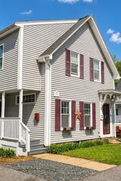
259 Main St Stoneham, MA 02180-2054
USE CATEGORY RA RB B CB HB C1 C2 MOR FM U MU See Additional Use Standards Restaurant P P P P P SP P or SPA/ SP P or SPA/ SP 4.4.2.F Retail, unless otherwise defined P or SPA/ SP P or SP A P or SPA/ SP P or SPA/ SP P or SPA/ SP - P P 4.4.2.G Sexually oriented business - - - - - - SPA/ SP - - - 4.4.2.H INSTITUTIONAL AND RECREA TIONAL USES Conference center - -…
Cap rate
Implied · in-place · derived from last sale + estimated NOIValue
AI, CAP & Alternative Use estimations · Realmo proprietary blendProperty tax & assessments
Tax year 2024Comparables
6 recent transactions · within 1.5 miComparable in this City


Similar Nearby for Sale


Similar Nearby for Lease


Property description
Physical attributes from public recordsZoning & alternative use
HB · Stoneham, MAUSE CATEGORY RA RB B CB HB C1 C2 MOR FM U MU See Additional Use Standards Restaurant P P P P P SP P or SPA/ SP P or SPA/ SP 4.4.2.F Retail, unless otherwise defined P or SPA/ SP P or SP A P or SPA/ SP P or SPA/ SP P or SPA/ SP - P P 4.4.2.G Sexually oriented business - - - - - - SPA/ SP - - - 4.4.2.H INSTITUTIONAL AND RECREA TIONAL USES Conference center - - - - - SP SP SPA/ SP - - - Crematorium - - - - SPA/ SP - - - - - - Hospital - - - - - - - P - - - Medical marijuana facility - - - - - - SPA/ SP - - - 4.4.3.A Medical schools, medical training facilities and health professions training facilities - - - - - - - SPA/ SP - - - Medical/ Dental clinics and laboratories - - - - - - - P - SPA - Medical / Dental / Veterinary office - - - - P P - P P - 20 USE CATEGORY RA RB B CB HB C1 C2 MOR FM U MU See Additional Use Standards Mortuary, funeral home - - SPA/ SP SP A/S P SPA/ SP - - - - - - INDUSTRIAL Electric utility substation - - - - - - - - SPA/ SP SPA/ SP - Industrial park - - - - - SP SP - P P - Laboratory P P P or SPA/ SP P P - Manufacturing, light - - - - - P P P P P - Passenger depots and terminals - - - - - SP SP - - - - Utility buildings, contractor’s storage warehouses and buildings, and wholesale distribution plants - - - - - SP SP - - - - Warehouse - - - - - P P - P - - Wholesale - - - - - - - - - - - ACCESSORY USES Accessory dwelling unit P P - - - - - - - - - 21 USE CATEGORY RA RB B CB HB C1 C2 MOR FM U MU See Additional Use Standards Accessory uses normal and incidental to uses permitted in each District P P P P P P P P P P 4.4.5.A Drive-through facility - - - - SP SP SP - - - 4.4.5.B Home occupation P P - - - - - - - - 4.2.1.C Note(s): For Recreation/Open Space District, see Section 4.5. 22 4.4 Use Standards 4.4.1. Residential Uses A. Dwelling, Multifamily dwellings. The following standards are applicable to multifamily dwellings in the Residence B district. a. Off-street parking shall be provided as required by Section 6, provided that: i. All parking spaces shall be located to the rear of the front building line. ii. If all the required parking area for a building containing dwelling units is enclosed within the structure of the buildings, the height regulation of Table of Dimensional Requirements may be raised by ten (10) feet for that building. b. Each structure shall be connected to and serviced by municipal water and sewer. c. In cases of public open space dedicated in fee to the Town, such as open space shall be maintained as a public area, accessible to the public. d.
Costs & Benchmarks
Operating expenses, capex projections, utility benchmarks, and submarket comparables — all in one view.
Risks
Flood, climate, environmental, title, and tenant-concentration risk — surfaced with mitigations and source citations.


