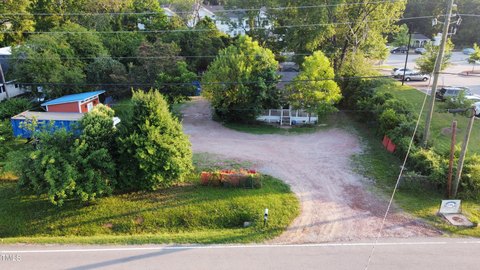
2400 Spg Frst Rd Raleigh, NC 27615-7530
Property profile & analytics
2400 Spg Frst Rd, Raleigh, NC 27615-7530
- Grocery and convenience stores
- 3,468 SF
- 1.08 lot acres
Property ID
US53-5774201
The Realmo ID is a unique identifier assigned to every property, incorporating country codes and precise geo-coordinates for 300x300-foot land blocks. It enables standardized data collection and seamless integration of disparate sources such as ownership, tax, title data and physical specifications. By aggregating current and historical records, the Realmo ID powers advanced analytics and delivers deep, verifiable insights for real estate professionals.
Location Intelligence
Current Use by Public Records
- Circle K / Grocery & Convenience Store
- ATM (Circle K) / Atm
Property Details for 2400 Spg Frst Rd
- Year built
- 1999
- Construction
- CONCRETE BLOCKS
- Lot size
- 1.08 lot acres
- Zone code
- NX-3
- Property type
- Grocery and convenience stores
- APN
- 1716.08-88-5402 0214342
- APU
- 1716088854020214342
Sales History
| Date | Price | Buyer | Seller | Deed Type | Mortgage |
|---|---|---|---|---|---|
| Dec 27, 2018 | — | Mdc Nc1 LP | Ri Cs2 LLC | Warranty Deed · related | — |
| Apr 16, 2004 | $1,530,000 | Ri Cs2 LLC | Circle K Stores INC | Grant Deed | — |
| Feb 26, 2004 | $1,693,000 | Circle K Stores INC | Csl Leasing INC | Grant Deed | — |
Value Estimations
based on Realmo’s proprietary methodology
-
AI approach
- Method
- Estimation
- ML approach
- $355,000
-
CAP approach
- CAP Return
- Estimation
- 6%
- $765,000
- 6.5%
- $705,000
- 7%
- $655,000
-
Comparable approach
- Method
- Estimation
- AI Estimate
- $680,000
Market price range: $242k - $680k
Get a detailed, property-specific estimation — fast and free
Location Insight
- Map
- Local Demand
- City
- Raleigh
- County
- Wake
- State
- North Carolina
- Longitude
- -78.6002
- Latitude
- 35.8607
- CBSA code
- 39580
- CBSA name
- RALEIGH-CARY, NC METROPOLITAN STATISTICAL AREA
Property Tax & Assessments
Tax date
Tax Amount
Assessed Land Value
Assessed Improvement Value
Total Assessed Value
Applied Tax Rate
Land Market Value
Improvement Market Value
Total Market Value
2023
$19,370
$762,129
$1,014,959
$1,777,088
-
$762,129
$1,014,959
$1,777,088