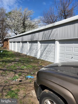
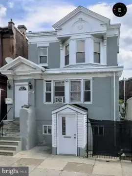
198th W Ashdale St Philadelphia, PA 19120
I-1 Light Industrial L-1 L-2 L-3 I-2 Medium Industrial G-1 G-2 Food Distribution Center I-3 Heavy Industrial LR I-P Port Industrial Port Industrial (.2) Map Symbols. (.a) The Industrial district map symbols are intended to provide a general, relative indication of the range of uses and activities allowed within the respective districts. "I" is used to indica…
Cap rate
Implied · in-place · derived from last sale + estimated NOIValue
AI, CAP & Alternative Use estimations · Realmo proprietary blendProperty tax & assessments
Tax year 2023Comparables
6 recent transactions · within 1.5 miComparable in this City


Similar Nearby for Sale


Similar Nearby for Lease


Property description
Physical attributes from public recordsZoning & alternative use
I1 · Philadelphia, PAI-1 Light Industrial L-1 L-2 L-3 I-2 Medium Industrial G-1 G-2 Food Distribution Center I-3 Heavy Industrial LR I-P Port Industrial Port Industrial (.2) Map Symbols. (.a) The Industrial district map symbols are intended to provide a general, relative indication of the range of uses and activities allowed within the respective districts. "I" is used to indicate a zoning district primarily intended to accommodate industrial uses. "IRMX" is used to indicate a zoning district that mixes industrial and other nonresidential use as well as residential development. "ICMX" is used to indicate a zoning district that mixes commercial and industrial. 298 (.b) The numeral following the dash in the Industrial district map symbols is a relative indicator of the density/intensity or use, with a "1" indicating the lowest intensity/use option. (b) Purposes. (.1) Philadelphia's Industrial zoning districts are primarily intended to accommodate manufacturing, warehousing, wholesale, and industrial uses. The district regulations are intended to: (.a) promote the economic viability of utilities, construction, manufacturing, goods movement and warehousing, resource production, research and development, equipment and facility services, and other industrial uses; (.b) encourage employment growth; and (.c) limit the encroachment of unplanned residential and other non-industrial development within active industrial areas. (.2) In the event of a conflict between any provision of this § 14-403 (Industrial and Industrial Mixed-Use Districts) and any other provision of this Zoning Code, the latter shall govern. (c) Descriptions. (.1) IRMX, Industrial Residential Mixed-Use District. The IRMX, Industrial Residential Mixed-Use district is primarily intended to accommodate a mix of very low-impact industrial uses, including artists and artisan industrial, and residential and neighborhood-oriented commercial uses. (.2) ICMX, Industrial Commercial Mixed-Use District. 299 The ICMX, Industrial Commercial Mixed-Use district is primarily intended to accommodate commercial and low-impact industrial uses. The district may serve as a buffer between Industrial districts and Commercial and Residential Districts. (.3)
Costs & Benchmarks
Operating expenses, capex projections, utility benchmarks, and submarket comparables — all in one view.
Risks
Flood, climate, environmental, title, and tenant-concentration risk — surfaced with mitigations and source citations.


