Back to Search
Property profile & analytics
OFF-MARKET
Estimated value
$720,000
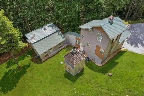
Commercial real estate
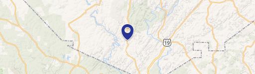
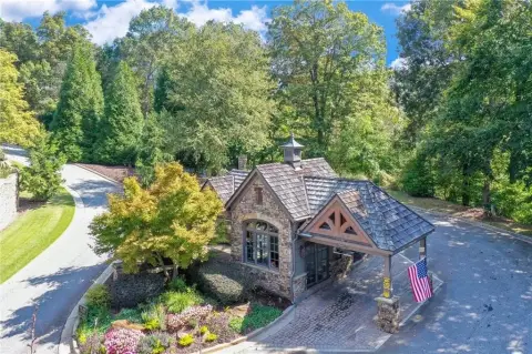
1976 Hwy 19th N Dahlonega, GA 30533-3802
Entity Owned
1-yr Hold
~
Est. High Equity
Property ID
US22-2412137
Property profile
Verified
Property type
Commercial real estate
Use group
COMMERCIAL (GENERAL)
Year built
2006
Total area
13,800 SF
Lot
4.38 ac (190,793 SF)
Zoning code
B2
APN
060A 008
UPID
US22-2412137
Cap rate & NOI
Priority signal for investors
Implied cap rate, NOI & suggested price
Cap rate vs submarket · NOI estimate · 3 price anchors
Implied cap rate, NOI & suggested price
Cap vs submarket · NOI estimate · 3 price anchors
Value estimations
Realmo proprietary · 4 methods
AI Approach
AI
by Request
CAP Approach
CAP
by Request
Comparable Approach
Comparable
$712k
Blend (final)
Blend
$720k
Owner & transaction history
Dahlonega City · 1 yrs held
Dahlonega City
since 2024
7 recorded transactions
Zoning & alternative use
B2 · Dahlonega, GA
Permitted uses
Permitted uses
Allowed · conditional · prohibited
Cap rate
Implied · in-place · derived from last sale + estimated NOI
Implied Cap rate
#1
Implied · in-place · NOI ÷ last sale
In-place · derived from last sale + estimated NOI
Cap rate, NOI & submarket benchmark
Implied cap rate vs Dahlonega submarket · NOI estimate · Typical band, median & reading
Implied cap rate, NOI & submarket benchmark
Cap vs Dahlonega submarket · NOI estimate · typical band, median & reading
Refine your cap rate
8-question underwriting flow
1.
Property current status — Going-In vs Stabilized
2.
Price for denominator — asking / offer / market
3.
Leasing status & lease structure (NNN / Gross)
4.
Tenant risk profile & vacancy assumption
5.
Upload T12 / rent roll / OM (optional)
Refine in 60 seconds, get exact suggested price
T12 upload · Submarket benchmarks · Sensitivity grid
Suggested price · 3 cap rate anchors
Income approach @ 5% / 7% / 9% — aggressive / typical / conservative
Suggested price at 5% / 7% / 9% cap
Aggressive / typical / conservative · Implied $/SF per anchor · Sensitivity grid
Suggested price at 5% / 7% / 9% cap
Aggressive / typical / conservative · implied $/SF · sensitivity
Value
AI, CAP & Alternative Use estimations · Realmo proprietary blendValue Estimations
Based on Realmo’s proprietary methodology
AI Approach
Method
Estimation
Statistic approach
by Request
ML approach
by Request
CAP Approach
CAP Return
Estimation
6%
by Request
6.5%
by Request
7%
by Request
Blend value · Realmo final
$720k
Range $648k – $792k · ±10%
Realmo estimate · informational only.
These numbers are calculated by our models from public records and may not reflect actual market value.
Not an appraisal.
Verify with a licensed appraiser before transacting. Realmo accepts no liability for divergence from real-world outcomes.
View the full estimation — every method, every assumption
Confidence drivers & risk notes · Custom comparable set · Free for first 3 / day
Full estimation methodology
Every method · every assumption · confidence drivers
Price per SF
Sale + rent benchmarks
Subject property
$52 / SF
Submarket sale & rent benchmarks
Median sale $/SF · Asking & closed rent · Submarket vacancy
Submarket sale & rent benchmarks
Median sale $/SF · asking & closed rent · submarket vacancy
Property tax & assessments
Tax year 2024Property tax & assessments
Tax year 2024
Tax billed
$7,834
Tax year 2024
Assessed value
$271,787
Assessed 2024
Previous assessed
$271,787
+0.0% YoY
Effective rate
2.88%
On assessed value
Assessed land
$262,800
Assessed improvement
$8,987
Land market value
$657,000
Improvement market value
$22,467
Total market value
$679,467
Applied tax rate
2.0000
Comparables
6 recent transactions · within 1.5 miComparable in this city
6 recent transactions
Comparable in this City

Similar Nearby for Sale

Similar Nearby for Lease


Recent comparable sales
Sale price & price/SF · Sale date & distance · Adjustments & confidence
Recent comparable sales
Sale price & $/SF · sale date & distance · adjustments
Property description
Physical attributes from public recordsBuilding & lot
Public records
Property type
Commercial real estate
Use group
COMMERCIAL (GENERAL)
Status
Off-Market
Year built
2006
Heating
CENTRAL
Cooling
CENTRAL
Stories
1
Total area
13,800 SF
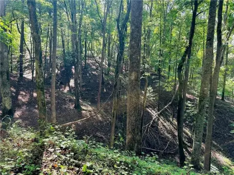
Lot
4.38 ac (190,793 SF)
Zoning code
B2
APN
060A 008
UPID
US22-2412137
Jurisdiction
LUMPKIN
Zoning & alternative use
B2 · Dahlonega, GA
Zoning B2 · permitted uses
B2 · Dahlonega, GA
Permitted & conditional uses
Allowed uses · Special-permit conditions · Prohibited uses
Permitted & conditional uses
Allowed · special-permit conditions · prohibited
Dahlonega. Always verify with local authorities before improvements.
Building & site characteristics
From public records
Year built
2006
Heating
CENTRAL
Cooling
Yes
Stories
1
Lot
4.38 ac
Current owner
From public records · entity-resolved
Dahlonega City
Entity
Mailing address
1976 HWY 19TH RD N, DAHLONEGA, GA 30533-3802
Mailing matches property
Yes
Owner-occupied
Yes
Ownership since
2024
Owner contacts — direct phone, email, and related entities
Decision-maker phone · Verified email · Related entities & filings
Owner contacts
Email · phone · related entities
Sales History
30 recorded events · public records
Date
Price
Buyer
Seller
Deed Type
Mortgage
Aug 29, 2024
$620,000
Dahlonega City
Wlw Investments LLC
Quit Claim Deed
related
—
Mar 2, 2020
—
Wlw Investments LLC
—
Deed Of Trust
related
$60,673 · Citizens Bk/ga
Nov 6, 2019
—
Wlw Investments LLC
—
Deed Of Trust
related
$250,000 · Citizens Bk/ga
Apr 11, 2016
—
Wlw Investments LLC
—
Trustees Deed
related
$50,410 · Southern Bk
Jun 15, 2011
—
Donald L Head
Head,don L & Patricia L
Quit Claim Deed
related
—
Jun 2, 2011
—
Wlw Investments LLC
Suntrust Bk
Quit Claim Deed
related
—
May 19, 2011
—
Don L Head
Federal Natl Mtg Assn Fnma
Grant Deed
related
—
Sep 15, 2008
—
Wlw Investments LLC
Walden,james W & Linda A
Quit Claim Deed
related
$1,393,026 · First Citizens Bank
Oct 4, 2007
—
James W Walden
Wlw Investments LLC
Warranty Deed
$150,000 · Countrywide Bank
Sep 20, 2005
—
Wlw Investments LLC
—
Trustees Deed
related
$940,000 · Mountain State Bank
Sep 12, 2005
—
Wlw Investments LLC
—
Trustees Deed
related
$100,000 · Mountain State Bank
—
—
Wlw Investments LLC
—
Loan Modification
related
$75,000 · First Citizens Bank
—
—
Wlw Investments LLC
—
Deed Of Trust
related
$365,500 · Citizens Bk/ga
—
—
Wlw Investments LLC
—
Loan Modification
related
$37,274 · Citizens Bk/ga
—
—
Wlw Investments LLC
—
Loan Modification
related
$1,546,666 · Southern Bk
—
—
Wlw Investments LLC
—
Loan Modification
related
$50,928 · Southern Bk
—
—
Wlw Investments LLC
—
Deed Of Trust
related
$1,849,914 · Southern Bk
—
—
Wlw Investments LLC
—
Deed Of Trust
related
$796,400 · Southern Bk
—
—
Wlw Investments INC
—
Loan Modification
related
$181,840 · Mountain State Bank
—
—
Wlw Investments INC
—
Loan Modification
related
$80,728 · Mountain State Bank
—
—
Wlw Investments LLC
—
Loan Modification
related
$1,192,580 · Mountain State Bank
—
—
Wlw Investments LLC
—
Loan Modification
related
$75,000 · First Citizens Bank
—
—
Wlw Investments LLC
—
Loan Modification
related
$75,000 · First Citizens Bank
—
—
Wlw Investments LLC
—
Loan Modification
related
$28,450 · Mountain State Bank
—
—
Wlw Investments LLC
—
Loan Modification
related
$320,300 · Citizens Bk/ga
—
—
Wlw Investments LLC
—
Loan Modification
related
$1,293,858 · First Citizens Bank
—
—
Wlw Investments LLC
—
Loan Modification
related
$1,296,213 · First Citizens Bank
—
—
Wlw Investments LLC
—
Loan Modification
related
$75,000 · First Citizens Bank
—
—
Wlw Investments LLC
—
Loan Modification
related
$75,000 · First Citizens Bank
—
—
Wlw Investments LLC
—
Loan Modification
related
$1,468,026 · First Citizens Bank
Coming soon
Costs & Benchmarks
Operating expenses, capex projections, utility benchmarks, and submarket comparables — all in one view.
Coming soon
Risks
Flood, climate, environmental, title, and tenant-concentration risk — surfaced with mitigations and source citations.
Try Rey
Ask anything about this address in plain English.
“Is 15.6% cap rate sustainable?” · “Best tenant mix for BU1?” · “What’s the redev upside?”
You own 1976 Hwy 19th N?
List it free. Reach 20,000 daily buyers.
We’ve already pulled the facts. Confirm photos + price and you’re live in 2 minutes.
List this address →
Full reports are paid
Unlock the full Property Analytics report
Start free for 7 days — no card required. Full owner contacts, all 4 valuations with methodology, refine flow, comparable adjustments, foot-traffic deep dive, export to PDF / CSV.


