Realmo Analytics
Unlock property reports, ownership, financials, or compile property list owners likely to sell.
We will call you to discuss how Realmo analytics may help you.
 Individually Owned
 For Sale
1 / 8
Property summary
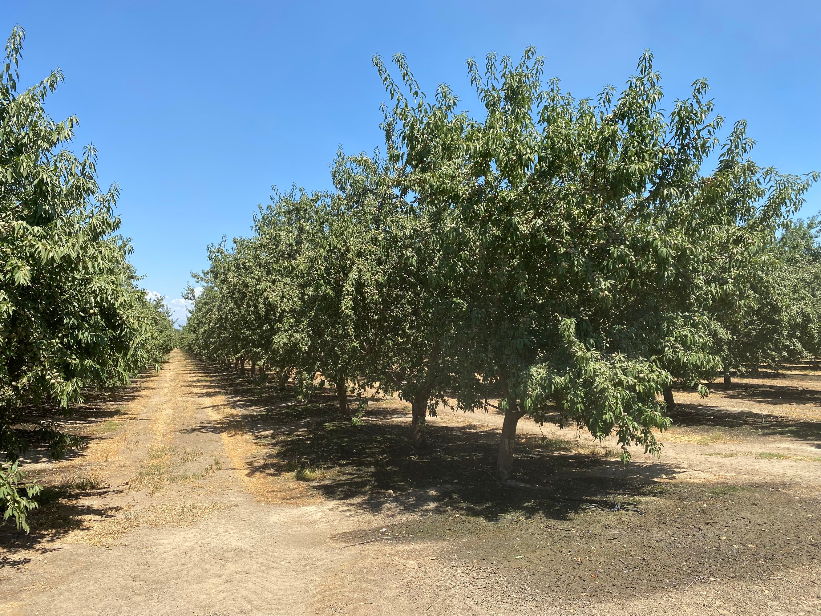
Location The subject property is located adjacent to 16029 Avenue 136, Tipton, CA 93272 approximately 5 miles east of Highway 99, south of Avenue 136 and on the east and west sides of Road 160. Description Description This opportunity is 685.67 +/- acres on nine parcels with 423.5 net acres of almonds, and approximately 230 acres of open land with a 45 acre sand pit. The property has multiple water sources; 6 irrigation wells, and surface water through Lower Tule River Irrigation District. This… ranch offers long term sustainable income and potential tax benefits. Parcel #’s Tulare County APNs 300-130-002, 015, 016, 025 & 300-080-021, 022 & 300-140-001, 002, and 020 Zoning AE40 - Exclusive Agriculture - 40 Acre minimum parcel size Crops Approximately, 292 acres of high yielding almonds (spaced at 22 x 16), and 131.5 acres of young almonds (spaced at 22 x 14). The almonds are 50% Nonpareil, 25% Monterey, and 25% Wood Colony, (see ranch map), and the historic production is on page 8 of flyer. Soil According to USDA California Revised Storie Index, Class 1 soils; see attached soils map for description. Water & Irrigation This entire ranch lies within the boundaries of and receives surface water from Lower Tule River Irrigation District. Seven turnouts on the canal give options for sending water across the property. The Lower Tule surface water has sources from both the Friant Canal as well as the Tule river giving it a strong allocation. In addition to surface water, Lower Tule has a great recharge capability for the district as a whole, which helps with SGMA requirements in the future. The almonds are irrigated with canal lift pumps, reservoirs, booster pumps, filter stations and fan jet systems. SGMA The Sustainable Groundwater Management Act passed in 2014 requires groundwater basins be sustainable by 2040 and requires Groundwater Sustainability Plans (GSP) by 2020. GSPs may limit the amount of well water pumped. For more information go to https://water.ca.gov/Programs/Goundwater-Management/SGMA-Groundwater-Management Price/Terms $20,570,000 ($30,000/acre) cash at close of escrow.
Ownership intelligence
Owner of record from public deeds, plus portfolio, hold profile and investor signals where the data supports them. Included with a plan.
Owner contacts
Skip-traced phones and e-mails of the owner. Included with a plan.
Debts
Recorded lenders, amounts and estimated maturities of the owner's loan book — included with a plan.
Property tax
No data for this sectionNo tax or assessment record is on file for this parcel in the county feed.
Value estimate
· Nov 2026No data for this sectionNo value estimate could be modeled: the record carries too little market input for this parcel.
Recently sold
No data for this sectionNo cleaned sale $/SF benchmark exists for this use type in this ZIP, submarket or county yet.
Cap rate analysis
No income signal is modeled for this parcel yet — the Cap Rates tab runs the workflow.
Zoning insight
No data for this sectionNo zoning code is on file for this parcel. Coverage grows with every catalog release.
Location intelligence
Location
Every figure names its source: public record, benchmark, or modeled. Coverage varies by property — thin data is stated as missing, never invented.
Comparables
4 properties nearbyComparable nearby


Similar Nearby for Sale
Instant AI valuation built from comps, income signals, and proprietary benchmarks.A defensible range, not a single guess.
from $199/month
Cap rate calculated from real income and expense signals, benchmarked against sales of similar assets nearby.
from $199/month
The recorded zoning designation, what the district officially allows, and the municipal source it comes from.
No zoning code is on file for this parcel. Zoning coverage grows with every catalog release — check back, or open Location Intelligence for use analysis of this corner.
Unlock the evidence behind ownership: portfolio, transactions, debt and any signals we can model, to help you decide who to contact next.
Registration is required before any owner information is shown.
Phones and e-mails of the people behind this property's owner, traced from licensed contact data.
Owner phones and e-mails come with a plan - traced from licensed contact data, with verification and Do-Not-Call flags on every number.
The mortgage data comes with a plan: recorded loans of the owner - lender, amount, rate and the estimated maturity - as part of the Ownership Intelligence workspace.
Registration is required before any owner information is shown.
Rey answers here. ChatGPT, Grok and Claude get the same data packet.
Includes: Price & PSF · Cap rate · Location · Zoning
Our comps and market reports get this label in your Google results.
 One click on Google
- 10 Targeted Leads
- 1 Full Property Report
- Lead Lists by Intent
- Signals & Scores
- Building Details
- Value Estimation
- Cap Rate Evaluation
- Liens & Mortgages
- Ownership & Contacts
- Local Market trends
- Zoning Insight
- Location Analytics
- 300 Targeted Leads a month
- 30 Full Property Reports
- Lead Lists by Intent
- Signals & Scores
- Building Details
- Value Estimation
- Cap Rate Evaluation
- Liens & Mortgages
- Ownership & Contacts
- Local Market trends
- Zoning Insight
- Location Analytics
- 1,500 Targeted Leads a month
- 150 Full Property Reports
- Lead Lists by Intent
- Signals & Scores
- Building Details
- Value Estimation
- Cap Rate Evaluation
- Liens & Mortgages
- Ownership & Contacts
- Local Market trends
- Zoning Insight
- Location Analytics
The PDF can’t be displayed here
Use Download PDF or Open in new tab above to view the sample report.
Sample leads
-
 Off Market
1201, CAPTAINS BAY RD, AK
Absentee
1201, CAPTAINS BAY RD, AK
-
 Off Market
AK
Absentee
AK
-
 Off Market
W, BROADWAY, AK
Absentee
W, BROADWAY, AK
-
 Off Market
551 W, BROADWAY, AK
Absentee
551 W, BROADWAY, AK
Sample leads
-
 Off Market
1404, ATS, AK
Loan from 20067.7% rateColumbia State Bank
1404, ATS, AK
-
 Off Market
1503, BALLYHOO RD, AK
Loan from 2009Columbia State Bank
1503, BALLYHOO RD, AK
-
 Off Market
721 E, DEPOT DR, AK
Loan from 2019Northrim Bank
721 E, DEPOT DR, AK
-
 Off Market
AK
Loan from 2019Northrim Bk
AK
Still being built. It lands here next, beside the two above.
The PDF can’t be displayed here
Your browser has no PDF viewer of its own.