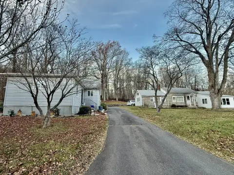
15 High St East Hampton, CT 06424-1001
-
McDonald's Restaurant Take-out & Catering
-
Stop & Shop Florist (Bike/Boat/Book/etc) Store Florist
c. The applicant shall demonstrate that commercial/retail uses are of such nature to enhance and augment the development proposal and that all uses shall be compatible and inter -related. d. Occupancy of commercial/retail uses shall not be permitted prior to substantial completion of all buildings proposed for each phase. In developments consisting of multip…
Cap rate
Implied · in-place · derived from last sale + estimated NOIValue
AI, CAP & Alternative Use estimations · Realmo proprietary blendProperty tax & assessments
Tax year 2023Comparables
6 recent transactions · within 1.5 miComparable in this City


Similar Nearby for Sale


Similar Nearby for Lease


Property description
Physical attributes from public recordsZoning & alternative use
C · East Hampton, CTc. The applicant shall demonstrate that commercial/retail uses are of such nature to enhance and augment the development proposal and that all uses shall be compatible and inter -related. d. Occupancy of commercial/retail uses shall not be permitted prior to substantial completion of all buildings proposed for each phase. In developments consisting of multiple phases, no more than thirty (30%) percent of the development of each phase shall conta in commercial/retail use. Buildings proposed for exclusive commercial/retail use shall not be permitted unless, or until the seventy percent: thirty percent (70%:30%) use ratio is evident. 2. Special Provisions for All Uses a. Public sewers and all available ut ilities are required to serve any development in this zone. All utilities including electricity, telephone and cable television shall be underground. b. Lot coverage shall not exceed fifty (50%) percent of the lot area. c. Landscaped open space is subject to review and approval by the Commission and shall cover a minimum of fifty (50%) percent of the lot area. d. There shall be a minimum effective buffer of at least fifty (50') feet between any proposed building or parking area or lot in this zone and any existin g residential property line. This buffer shall be one hundred (100') feet to any existing residence. e. For any proposed use in this zone, the applicant shall supply, in sufficient quantities, architectural drawings of all buildings, structures and signs. Such drawings shall consist of, but not be limited to: exterior elevations, general floor plans, at least one perspective drawing showing structures, where applicable, types of exterior materials proposed for use and proposed signs as to their location and general design. f. The design of all buildings and structures to be erected in this zone shall be subject to the approval of the Commission. The design of all buildings and other structures including the building materials and exterior elevations shall be de signed to be visually consistent with the area in which it is located, to accomplish an effective, non -abrupt transition of styles between it and areas of established development. The design shall preserve and enhance the appearance of the community and shall not have any detrimental effect on the property values of the area. g. The proposal shall include a forty (40') foot effective buffer around the entire perimeter of the parcel except for that portion that abuts a major thoroughfare, or those areas requir ing larger buffers as described in Section 5.5.D.2.D.
No recorded transactions found for this property.
Costs & Benchmarks
Operating expenses, capex projections, utility benchmarks, and submarket comparables — all in one view.
Risks
Flood, climate, environmental, title, and tenant-concentration risk — surfaced with mitigations and source citations.


