1405 60Th St, Kansas City, MO 64118
- Commercial real estate
- 21.93 lot acres
Current Use by Public Records
- Commercial real estate
Property Details for 1405 60Th St
- Lot size
- 21.93 lot acres
- Property type
- Commercial real estate
Description
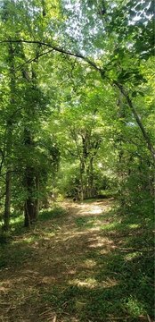
This exceptional 21.93-acre property in Kansas City, Missouri, presents a unique development opportunity. Located at 1405 NW 60th Street, in Clay County, zip code 64118, this rectangular parcel boasts a partially cleared area suitable for immediate construction, complemented by mature trees offering privacy. The land is situated adjacent to Oakwood Forest to the south and southwest, providing a tranquil setting. While a home currently occupies the property, it's not visible from the 60th Street entrance and is currently occupied, requiring prior permission for access. The property offers convenient access to major highways, enhancing its appeal for various development projects. Further details, including additional photos and an unbranded drone video, are available via the associated residential listing (MLS # 2514001). The asking price for this expansive land parcel is $400,000. This represents a significant opportunity for investors and developers seeking a substantial land holding in a desirable Kansas City location.
Value Estimations
-
AI approach
-
CAP approach
-
Comparable approach
-
Alternative Use
Get a detailed, property-specific estimation — fast and free
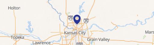
Location Insight
- Map
- Local Demand
- City
- Kansas City
- County
- Clay
- State
- Missouri
- Longitude
- -94.5980925
- Latitude
- 39.2030382