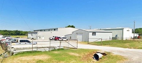
13701 Hwy 51 Sand Springs, OK 74063-4494
Property profile & analytics
13701 Hwy 51, Sand Springs, OK 74063-4494
- Flex space
- 198,350 SF
- 113.93 lot acres
Property ID
US69-0928026
The Realmo ID is a unique identifier assigned to every property, incorporating country codes and precise geo-coordinates for 300x300-foot land blocks. It enables standardized data collection and seamless integration of disparate sources such as ownership, tax, title data and physical specifications. By aggregating current and historical records, the Realmo ID powers advanced analytics and delivers deep, verifiable insights for real estate professionals.
Location Intelligence
Current Use by Public Records
- Flex space
Property Details for 13701 Hwy 51
- Year built
- 2012
- Construction
- STEEL FRAME
- Lot size
- 113.93 lot acres
- Zone code
- IM
- Property type
- Flex space
- APN
- 99116-91-16-67832
- APU
- 99116911667832
Sales History
| Date | Price | Buyer | Seller | Deed Type | Mortgage |
|---|---|---|---|---|---|
| — | — | Webco Industries INC | — | Deed Of Trust · related | — |
Value Estimations
based on Realmo’s proprietary methodology
-
Alternative Use
- Use
- Estimation
- INDUSTRIAL (GENERAL)
- $13,040,000 Current use
- NEIGHBORHOOD: SHOPPING CENTER
- $14,225,000 Change: +9% Conversion: Difficult
Get a detailed, property-specific estimation — fast and free
Location Insight
- Map
- Local Demand
- City
- Sand Springs
- County
- Tulsa
- State
- Oklahoma
- Longitude
- -96.1479
- Latitude
- 36.1317
- CBSA code
- 46140
- CBSA name
- TULSA, OK METROPOLITAN STATISTICAL AREA
Property Tax & Assessments
Tax date
Tax Amount
Assessed Land Value
Assessed Improvement Value
Total Assessed Value
Applied Tax Rate
Land Market Value
Improvement Market Value
Total Market Value
2023
$293,505
$88,209
$2,298,208
$2,386,417
-
$801,900
$20,892,800
$21,694,700