12141 Rte 6th 6 Corry, PA 16407-9542
Property profile & analytics
12141 Rte 6th 6, Corry, PA 16407-9542
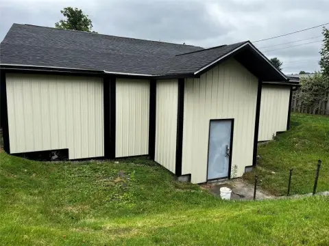
- Warehouses
- 29,600 SF
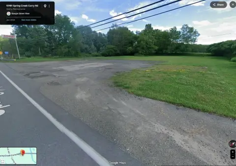
- 30.01 lot acres
Property ID
US73-1694168
The Realmo ID is a unique identifier assigned to every property, incorporating country codes and precise geo-coordinates for 300x300-foot land blocks. It enables standardized data collection and seamless integration of disparate sources such as ownership, tax, title data and physical specifications. By aggregating current and historical records, the Realmo ID powers advanced analytics and delivers deep, verifiable insights for real estate professionals.
Location Intelligence
Current Use by Public Records
- Warehouses
Property Details for 12141 Rte 6th 6
- Year built
- 1975
- Construction
- WOOD
- Lot size
- 30.01 lot acres
- Zone code
- B1
- Property type
- Warehouses
- APN
- 03-002-002.0-015.00
- APU
- 3002002001500
Sales History
| Date | Price | Buyer | Seller | Deed Type | Mortgage |
|---|---|---|---|---|---|
| Jul 10, 2019 | $2,000,000 | National Retail Properties Trust | Swift Auto Auction INC | Grant Deed | — |
| Dec 19, 2016 | — | Swift Auto Auction INC | — | Deed · related | $550k · Northwest Bk |
| Jul 27, 2016 | — | Swift Auto Auction INC | — | Deed · related | $100k · Northwest Bk |
| May 12, 2016 | — | Swift Auto Auction INC | — | Deed · related | $375k · Northwest Bk |
| — | — | Swift Auto Auction INC | — | Deed Of Trust · related | $100k · First Nat'l Bk/pa |
| — | — | Swift Auto Auction INC | — | Deed Of Trust · related | $100k · Northwest Bk |
| — | — | Swift Auto Auction INC | — | Deed Of Trust · related | $200k · First National Bank Pa |
| — | — | Swift Auto Auction INC | — | Deed Of Trust · related | $400k · Northwest Svgs Bk |
| — | — | Swift Auto Auction INC | — | Deed Of Trust · related | $439k · Wells Fargo Bk |
| — | — | Swift Auto Auction INC | — | Deed Of Trust · related | $375k · First National Bank Pa |
| — | — | Swift Auto Auction INC | — | Deed Of Trust · related | $375k · Northwest Bk |
| — | — | Swift Auto Auction INC | — | Deed Of Trust · related | $310k · National Bank Of North East |
| — | — | Swift Auto Auction INC | — | Deed Of Trust · related | $550k · Northwest Bk |
| — | — | Swift Auto Auction INC | — | Deed Of Trust · related | $9k · Telmark LLC |
| — | — | Swift Auto Auction | — | Deed Of Trust · related | $900k · Wells Fargo Financial Leasing |
Value Estimations
based on Realmo’s proprietary methodology
-
Comparable approach
- Method
- Estimation
- Statistic Estimate
- $1,686,000
- AI Estimate
- $1,422,000
Market price range: $655k - $1.69MMarket price range: $612k - $1.42M -
Alternative Use
- Use
- Estimation
- WAREHOUSE, STORAGE
- $1,095,000 Current use
- APARTMENT HOUSE (5+ UNITS)
- $2,610,000 Change: +139% Conversion: Difficult
- OFFICE BUILDING
- $2,250,000 Change: +106% Conversion: Difficult
- RESTAURANT
- $2,175,000 Change: +99% Conversion: Difficult
- RETAIL STORES
- $2,120,000 Change: +94% Conversion: Moderate
- AUTO REPAIR, GARAGE
- $2,095,000 Change: +92% Conversion: Easy
- COMMERCIAL (GENERAL)
- $1,400,000 Change: +28% Conversion: Difficult
Get a detailed, property-specific estimation — fast and free
Location Insight
- Map
- Local Demand
- City
- Corry
- County
- Erie
- State
- Pennsylvania
- Longitude
- -79.7178
- Latitude
- 41.9167
- CBSA code
- 21500
- CBSA name
- ERIE, PA METROPOLITAN STATISTICAL AREA
Property Tax & Assessments
Tax date
Tax Amount
Assessed Land Value
Assessed Improvement Value
Total Assessed Value
Applied Tax Rate
Land Market Value
Improvement Market Value
Total Market Value
2023
$17,830
$89,300
$717,100
$806,400
-
$89,300
$717,100
$806,400