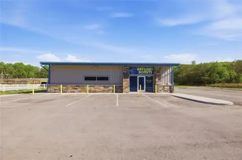
11950 Hwy 51 Sand Springs, OK 74063-4495
C. Purposes of the CG Commercial General District The CG District is designed to: 1. Accommodate existing development of mixed commercial uses which are well established, while providing a degree of protection to adjacent residential areas. 2. Accommodate the grouping of certain commercial and light industrial uses which are compatible with one another. D. P…
Cap rate
Implied · in-place · derived from last sale + estimated NOIValue
AI, CAP & Alternative Use estimations · Realmo proprietary blendProperty tax & assessments
Tax year 2023Comparables
6 recent transactions · within 1.5 miComparable in this City


Similar Nearby for Sale


Similar Nearby for Lease


Property description
Physical attributes from public recordsZoning & alternative use
CG · Sand Springs, OKC. Purposes of the CG Commercial General District The CG District is designed to: 1. Accommodate existing development of mixed commercial uses which are well established, while providing a degree of protection to adjacent residential areas. 2. Accommodate the grouping of certain commercial and light industrial uses which are compatible with one another. D. Purposes of the CBD Central Business District The purposes of the Central Business District are to: 1. Accommodate and encourage the most desirable and most productive use of land, with regard to the regulation of building height, floo r area or land coverage, within the central business area of the City as designated by the Comprehensive Plan. 2. Encourage a diversity of uses which mutually benefit from close proximity to, and from the available services of, the network of downtown bu siness and collector streets. 3. Preserve and promote the public and private investment in the existing central business area. E. Purpose of the CH Commercial High Intensity District The CH District is designed to accommodate high intensity commercial and related uses. 7-3 Zoning Code of the City of Sand Springs
Costs & Benchmarks
Operating expenses, capex projections, utility benchmarks, and submarket comparables — all in one view.
Risks
Flood, climate, environmental, title, and tenant-concentration risk — surfaced with mitigations and source citations.


