100 Samuels Rd Sandpoint, ID 83864-5977
Property profile & analytics
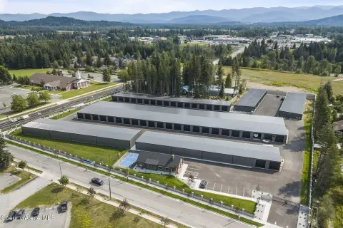
100 Samuels Rd, Sandpoint, ID 83864-5977
- Industrial properties
- 1,440 SF
- 40.00 lot acres
Property ID
US27-1027599
The Realmo ID is a unique identifier assigned to every property, incorporating country codes and precise geo-coordinates for 300x300-foot land blocks. It enables standardized data collection and seamless integration of disparate sources such as ownership, tax, title data and physical specifications. By aggregating current and historical records, the Realmo ID powers advanced analytics and delivers deep, verifiable insights for real estate professionals.
Location Intelligence
Current Use by Public Records
- Sandpoint Equipment Rental / (Bike/Boat/Book/etc) Store / Rental Equipment Company
- Pain Free Excavation / General Contractor / Construction Company
Property Details for 100 Samuels Rd
- Year built
- 1979
- Lot size
- 40.00 lot acres
- Property type
- Industrial properties
- APN
- RP59N01W320750A
- APU
- RP59N01W320750A
Sales History
| Date | Price | Buyer | Seller | Deed Type | Mortgage |
|---|---|---|---|---|---|
| Dec 14, 2021 | — | Dominion Empire LLC | — | Deed · related | $1.5M · Banner Bank |
| Nov 15, 2019 | — | Pjd Partnership | Leonard A Malloy | Correction Deed · related | — |
| Jan 23, 2018 | — | Leonard A Maloy | Wendy Malopy | Quit Claim Deed · related | — |
| Dec 31, 2013 | — | Pjd Partnership | Patrick L Malloy | Quit Claim Deed · related | — |
| Dec 24, 2007 | — | Patrick L Malloy | Mary L Malloy | Intrafamily Transfer · related | — |
Value Estimations
based on Realmo’s proprietary methodology
-
AI approach
-
CAP approach
-
Comparable approach
-
Alternative Use
Get a detailed, property-specific estimation — fast and free
Location Insight
- Map
- Local Demand
- City
- Sandpoint
- County
- Bonner
- State
- Idaho
- Longitude
- -116.494
- Latitude
- 48.4258
- CBSA code
- 41760
- CBSA name
- SANDPOINT, ID MICROPOLITAN STATISTICAL AREA
Property Tax & Assessments
Tax date
Tax Amount
Assessed Land Value
Assessed Improvement Value
Total Assessed Value
Applied Tax Rate
Land Market Value
Improvement Market Value
Total Market Value
2024
$8,782
$830,000
$1,414,771
$2,244,771
-
$830,000
$1,414,771
$2,244,771