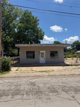
10 Hwy 81 Duncan, OK 73533-2651
Property profile & analytics
10 Hwy 81, Duncan, OK 73533-2651
- Strip malls
- 3,695 SF
Property ID
US69-1916031
The Realmo ID is a unique identifier assigned to every property, incorporating country codes and precise geo-coordinates for 300x300-foot land blocks. It enables standardized data collection and seamless integration of disparate sources such as ownership, tax, title data and physical specifications. By aggregating current and historical records, the Realmo ID powers advanced analytics and delivers deep, verifiable insights for real estate professionals.
Location Intelligence
Current Use by Public Records
- Strip malls
Property Details for 10 Hwy 81
- Year built
- 1970
- Construction
- TILT-UP CONCRETE
- Property type
- Strip malls
- Property subtype
- Shopping centers
- APN
- 1001-00-152-004-0-000-00
- APU
- 100100152004000000
Sales History
| Date | Price | Buyer | Seller | Deed Type | Mortgage |
|---|---|---|---|---|---|
| Sep 15, 2023 | $130,000 | Bishop Commercial Rentals LLC | First Bank & Trust Co | Warranty Deed | $102k · Legacy Bank |
| Oct 6, 2009 | $119,000 | Scott L Rice | Vic Whitney LLC | Warranty Deed | $156k · First Bank & Trust Co |
Value Estimations
based on Realmo’s proprietary methodology
-
AI approach
-
CAP approach
-
Comparable approach
-
Alternative Use
Get a detailed, property-specific estimation — fast and free
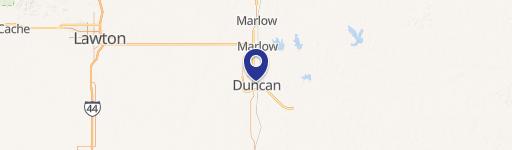
Location Insight
- Map
- Local Demand
- City
- Duncan
- County
- Stephens
- State
- Oklahoma
- Longitude
- -97.968
- Latitude
- 34.502
- CBSA code
- 20340
- CBSA name
- DUNCAN, OK MICROPOLITAN STATISTICAL AREA
Property Tax & Assessments
Tax date
Tax Amount
Assessed Land Value
Assessed Improvement Value
Total Assessed Value
Applied Tax Rate
Land Market Value
Improvement Market Value
Total Market Value
2023
$1,259
$5,802
$8,960
$14,762
-
$52,747
$81,453
$134,200