1400 Westport Pkwy Fort Worth, TX 76177
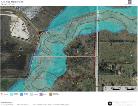
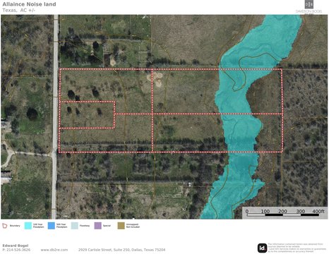
This exceptional 138-acre commercial land parcel is strategically located in the Alliance Texas submarket of North Fort Worth, within Tarrant County, at 1400 Westport Pkwy, zip code 76177. The property is zoned for both Agricultural (AG) and Industrial (I) uses, offering significant development flexibility. Situated near Alliance Airport, Alliance Town Center, and Circle T Ranch, this land benefits from the robust infrastructure, substantial employment base, and considerable economic opportunities presented by the rapidly growing Alliance Texas submarket. The surrounding area, including Haslet, Argyle, Northlake, and Justin, has experienced remarkable growth in residential development, infrastructure improvements, and population increase over the past five years. This surge in new home construction has fueled demand for industrial/logistics, retail, and mixed-use developments. The Alliance Texas submarket itself is a nearly 27,000-acre master-planned community featuring a large employment base, master-planned residential communities, e-commerce and logistics centers, retail power centers, and corporate campuses. This prime location presents a unique investment opportunity to capitalize on the continued expansion and economic vitality of this thriving North Texas region. The property's latitude and longitude coordinates are 32.972307 and -97.3192743 respectively.
Cap rate
Implied · in-place · derived from last sale + estimated NOIValue
AI, CAP & Alternative Use estimations · Realmo proprietary blendComparables
6 recent transactions · within 1.5 miComparable in this City


Similar Nearby for Sale


Similar Nearby for Lease


Property description
Physical attributes from public recordsZoning & alternative use
No recorded transactions found for this property.
Costs & Benchmarks
Operating expenses, capex projections, utility benchmarks, and submarket comparables — all in one view.
Risks
Flood, climate, environmental, title, and tenant-concentration risk — surfaced with mitigations and source citations.


