Permitted Active Gravel
For Sale
$4,750,000
6606 S County Road 213, Deer Trail, CO 80105
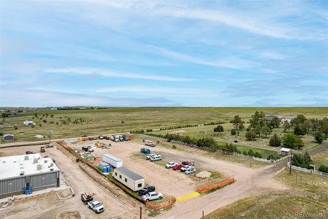
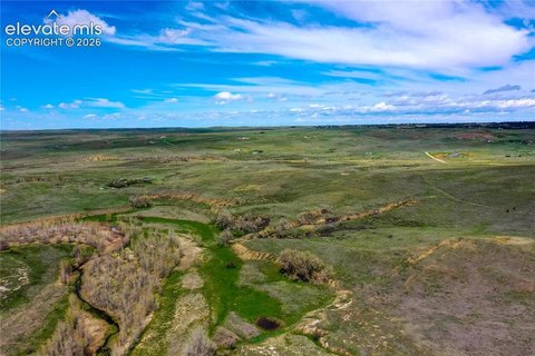
Active, permitted gravel pit with mining permit, reclamation plan, and water resources for aggregate extraction.
Property SizeContact for details
Days on Market109
Property Features for 6606 S County Road 213
General Information
Standard status
Active
Property subtype
Land
Listing Agency:
Unique Properties, Inc
Listed By:
Richard Bowler · License #EA.001326291
(720) 849-2255
Source:
Uniqueprop
Added: Jun 25
Changed: Oct 10
Last Checked: Oct 9 at 4:20PM
Displayed information is deemed reliable but is not guaranteed and should be independently verified. All listing content including descriptions, pricing, images are the copyrighted material of Unique Properties, Inc
Investment Insights
Based on property information with market context.
The Deer Trail Pit is a permitted, active gravel pit designed for mining operations using a phased approach. A geologic survey estimates approximately 1.2 million cubic yards (1,800,000 tons) of concrete sand material and other marketable aggregates. The site includes an approved reclamation plan with additional imported topsoil and stockpiled overburden for future reclamation activity.
The property is located about 1.75 miles from the Town of Deer Trail and the Union Pacific Railroad, with access to a nearby I-70 exit roughly 2 miles away. Additional site context includes distances of approximately 40 miles from the I-70 and E-470 interchange and about 30 miles from Limon.
This offering includes the real estate, mineral and water rights, the business, and equipment. The commercial well is drilled to 625 feet and pumps 300 GPM into two lined ponds or water storage facilities used for washing materials throughout the duration of all seven mining phases, with operations contemplated for a 25-year period. The property also includes permitted water volumes for long-term operations, as stated in the provided information.
The property is located about 1.75 miles from the Town of Deer Trail and the Union Pacific Railroad, with access to a nearby I-70 exit roughly 2 miles away. Additional site context includes distances of approximately 40 miles from the I-70 and E-470 interchange and about 30 miles from Limon.
This offering includes the real estate, mineral and water rights, the business, and equipment. The commercial well is drilled to 625 feet and pumps 300 GPM into two lined ponds or water storage facilities used for washing materials throughout the duration of all seven mining phases, with operations contemplated for a 25-year period. The property also includes permitted water volumes for long-term operations, as stated in the provided information.
Key Highlights
- Active, permitted gravel pit with mining permit in place and approved reclamation plan/permit
- Estimated 1.2 million CY (1,800,000 tons) of concrete sand material and other marketable aggregates to be mined
- Located 1.75 miles from Deer Trail and the Union Pacific Railroad; about 2 miles from I‑70 exit 328
Property Analytics
Unlock full access to Insights
Subscribe to Realmo Intelligence
Open Analytics
Current Use
Location Intelligence
Trade Area within ½ mile
1
Businesses Nearby
Explore this area
Business Placement
Demographics for 80105, CO
1,771
Population
822
Households
2.2
Avg Household Size
37
Median Age
18%
College-Educated
91%
High-School Grad
396.2 sq mi
ZIP Area
4
Density / Sq Mi
$86,964
Median Household Income
$46,523
Median Earnings
$943
Median Rent
$374,400
Median Home Value
Check the figures for this property
Cap Rate, Value Estimation, Potential NOI and more
View Realmo Analytics
Market
Vacancy Rate% for Industrial in West region

Questions? Ask Rey
Realmo’s AI knows this listing — price, zoning, demand, history. Ask anything.





Frequently Asked Questions
What type of property is this?
Mining land & claim - Active, permitted gravel pit with mining permit, reclamation plan, and water resources for aggregate extraction.
Where is this mining land & claim located?
The property is located at 6606 S County Road 213 Deer Trail, CO.
What is the asking price?
The asking price for this property is $4,750,000.
What are key features of this property?
This property features: Active, permitted gravel pit with mining permit in place and approved reclamation plan/permit; Estimated 1.2 million CY (1,800,000 tons) of concrete sand material and other marketable aggregates to be mined; Located 1.75 miles from Deer Trail and the Union Pacific Railroad; about 2 miles from I‑70 exit 328