216 Acres JP Cave Road, Sherman, TX 75090
- Added:
- Feb 25, 2026
- Days on Market:
- 99
- Last Refresh:
- Jun 4 at 10:06 pm
Property Features for 216 Acres JP Cave Road
General Information
- Property type
- Land
- Property subtype
- Other
- Vegetation
- Cleared, Wooded, Grassed
- Standard status
- Active
- APN
- 122309
- Lot size
- 216.00 Acres
Listing agent Terrin Bertholf License #0649544 (903) 267-1573
Listing office Bertholf Commercial Real Estate Denison, TX (903) 267-1573
Listing date Feb 25, 2026
Copyright © 2026 North Texas Real Estate Information Systems, Inc. All rights reserved. All information provided by the listing agent/broker is deemed reliable but is not guaranteed and should be independently verified.
HighLights
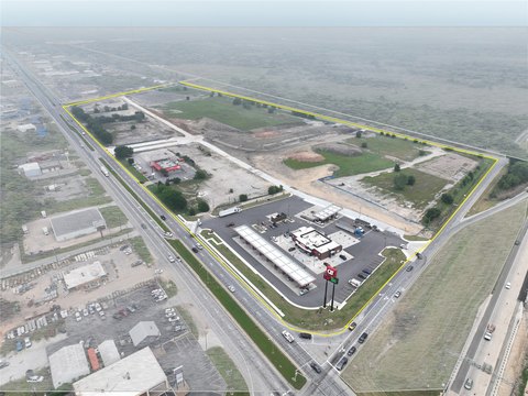
- 217 acres of developable land, conveniently located within 5 miles of major highways (US Hwy 75, Hwy 82) and downtown Sherman.
- Boasting over 2,400 feet of road frontage on JP Cave Rd, ideal for development.
- Gentle topography ensures ease of building, with no flood plain and minimal wetlands.
- Located in Sherman ISD.
- Minimal easements and agriculturally assessed.
- Located in Sherman sewer CCN and both Pink Hill water CCN and Sherman water CCN.
Overview
The tract is located within about five miles of US Highway 75, Highway 82, and downtown Sherman. It includes more than 2,400 feet of road frontage along JP Cave Rd, providing strong visibility and access for development planning. The property sits within Sherman ISD and is partially located in the city’s ETJ and partially in the county. The site is also noted as being within the Sherman sewer CCN and both the Pink Hill water CCN and Sherman water CCN, with water and sewer roughly 2 miles to the west.
With its frontage, topography, and limited impediment from floodplain and easements, the property is well suited for investors or developers looking for a sizable land position near key Sherman corridors. The mix of ETJ and county location may appeal to parties evaluating phased or jurisdiction-aware development strategies, while the existing agricultural assessment can be advantageous for holding value prior to planning.
Current Use by Public Records
Map
- City
- Sherman
- County
- Grayson
- State
- Texas
- Longitude
- -96.5341798
- Latitude
- 33.62304