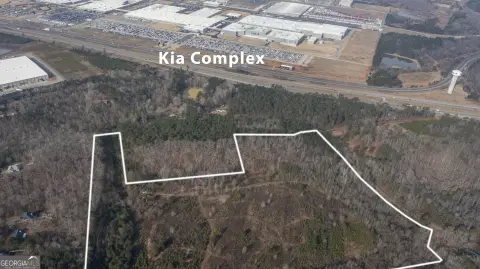
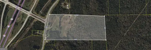
Us Hwy 29 West Point, GA 31833
Property profile & analytics
Us Hwy 29, West Point, GA 31833
- Industrial land
- 2.50 lot acres
Property ID
US22-2691815
The Realmo ID is a unique identifier assigned to every property, incorporating country codes and precise geo-coordinates for 300x300-foot land blocks. It enables standardized data collection and seamless integration of disparate sources such as ownership, tax, title data and physical specifications. By aggregating current and historical records, the Realmo ID powers advanced analytics and delivers deep, verifiable insights for real estate professionals.
Location Intelligence
Current Use by Public Records
- Industrial land
Property Details for Us Hwy 29
- Lot size
- 2.50 lot acres
- Zone code
- 17-I-1
- Property type
- Industrial land
- APN
- 0943A001006
- APU
- 0943A001006
Sales History
| Date | Price | Buyer | Seller | Deed Type | Mortgage |
|---|---|---|---|---|---|
| Dec 30, 2021 | — | Nassau Sound Associates LLC | Henry And Lura Miller House LLC | Warranty Deed | — |
| Aug 1, 2014 | — | Georgia Trust Of Historic Preserv | Johnson,a Stephen | Grant Deed · related | — |
Value Estimations
based on Realmo’s proprietary methodology
-
AI approach
-
CAP approach
-
Comparable approach
-
Alternative Use
Get a detailed, property-specific estimation — fast and free
Location Insight
- Map
- Local Demand
- City
- West Point
- County
- Troup
- State
- Georgia
- Longitude
- -85.1686
- Latitude
- 32.8854
- CBSA code
- 29300
- CBSA name
- LAGRANGE, GA-AL MICROPOLITAN STATISTICAL AREA
Property Tax & Assessments
Tax date
Tax Amount
Assessed Land Value
Assessed Improvement Value
Total Assessed Value
Applied Tax Rate
Land Market Value
Improvement Market Value
Total Market Value
2023
$437
$12,280
$0.00
$12,280
-
$30,700
$0.00
$30,700