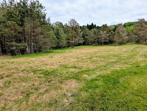
Laurel Ln Port Allegany, PA 16743
Property profile & analytics
Laurel Ln, Port Allegany, PA 16743
- Commercial land
- 0.94 lot acres
Property ID
US73-4500584
The Realmo ID is a unique identifier assigned to every property, incorporating country codes and precise geo-coordinates for 300x300-foot land blocks. It enables standardized data collection and seamless integration of disparate sources such as ownership, tax, title data and physical specifications. By aggregating current and historical records, the Realmo ID powers advanced analytics and delivers deep, verifiable insights for real estate professionals.
Location Intelligence
Current Use by Public Records
- Commercial land
Property Details for Laurel Ln
- Lot size
- 0.94 lot acres
- Property type
- Commercial land
- APN
- 14-001. -604.02.
- APU
- 1400160402
Sales History
| Date | Price | Buyer | Seller | Deed Type | Mortgage |
|---|---|---|---|---|---|
| May 1, 2026 | $65,000 | Mcfall Debra | Hauck Lisa | Deed | — |
| Mar 29, 2021 | $5,000 | Daniel Major | Charles W Yeager | Deed | — |
| Dec 2, 2019 | — | Gage Caulkins | Barbara J Major | Fiduciary Deed | — |
| Dec 28, 2018 | — | Douglas E Watson | Choice Property Holdings LLC | Deed | — |
| Feb 15, 2017 | $2,500 | Kyle A Bachman | Douglas E Watson | Deed | — |
| Jan 23, 2017 | $4,000 | Chad T Jackson | Brandon M Bliss | Deed | — |
Value Estimations
based on Realmo’s proprietary methodology
-
AI approach
-
CAP approach
-
Comparable approach
-
Alternative Use
Get a detailed, property-specific estimation — fast and free
Location Insight
- Map
- Local Demand
- City
- Port Allegany
- County
- Mckean
- State
- Pennsylvania
- Longitude
- -78.2856
- Latitude
- 41.8248
- CBSA code
- 14620
- CBSA name
- BRADFORD, PA MICROPOLITAN STATISTICAL AREA
Property Tax & Assessments
Tax date
Tax Amount
Assessed Land Value
Assessed Improvement Value
Total Assessed Value
Applied Tax Rate
Land Market Value
Improvement Market Value
Total Market Value
2024
$438
$11,280
$0.00
$11,280
-
$11,280
$0.00
$11,280