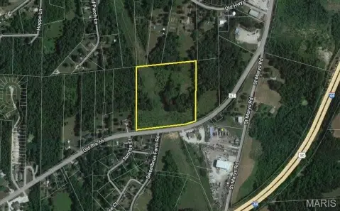
Hwy At Villa Ridge, MO 63089
Property profile & analytics
Hwy At, Villa Ridge, MO 63089
- Commercial land
- 5,837 SF
- 9.00 lot acres
Property ID
US48-0269699
The Realmo ID is a unique identifier assigned to every property, incorporating country codes and precise geo-coordinates for 300x300-foot land blocks. It enables standardized data collection and seamless integration of disparate sources such as ownership, tax, title data and physical specifications. By aggregating current and historical records, the Realmo ID powers advanced analytics and delivers deep, verifiable insights for real estate professionals.
Location Intelligence
Current Use by Public Records
- Commercial land
Property Details for Hwy At
- Year built
- 1985
- Lot size
- 9.00 lot acres
- Zone code
- CA
- Property type
- Commercial land
- APN
- 18-6-13.0-0-006-040.500
- APU
- 1861300006040500
Sales History
| Date | Price | Buyer | Seller | Deed Type | Mortgage |
|---|---|---|---|---|---|
| Aug 21, 2009 | $1,550,000 | Westland Properties LLC | Ports Petroleum Co INC | Warranty Deed | — |
| Jun 14, 2007 | — | Ports Petroleum Co INC | — | Deed Of Trust · related | $17M · Wells Fargo Bank |
| Feb 2, 2006 | $1,455,000 | Ports Petroleum Co INC | Bauman Properties LLC | Warranty Deed | — |
Value Estimations
based on Realmo’s proprietary methodology
-
AI approach
-
CAP approach
-
Comparable approach
-
Alternative Use
Get a detailed, property-specific estimation — fast and free
Location Insight
- Map
- Local Demand
- City
- Villa Ridge
- County
- Franklin
- State
- Missouri
- Longitude
- -90.8534
- Latitude
- 38.474
- CBSA code
- 41180
- CBSA name
- ST. LOUIS, MO-IL METROPOLITAN STATISTICAL AREA
Property Tax & Assessments
Tax date
Tax Amount
Assessed Land Value
Assessed Improvement Value
Total Assessed Value
Applied Tax Rate
Land Market Value
Improvement Market Value
Total Market Value
2023
$7,638
$0.00
$0.00
$107,592
-
$896,600
$0.00
$896,600