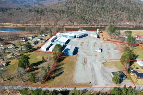
County Hwy 67 Hancock, NY 13783
Property profile & analytics
County Hwy 67, Hancock, NY 13783
- Mining land & claims
- 165.87 lot acres
Property ID
US63-4884624
The Realmo ID is a unique identifier assigned to every property, incorporating country codes and precise geo-coordinates for 300x300-foot land blocks. It enables standardized data collection and seamless integration of disparate sources such as ownership, tax, title data and physical specifications. By aggregating current and historical records, the Realmo ID powers advanced analytics and delivers deep, verifiable insights for real estate professionals.
Location Intelligence
Current Use by Public Records
- Mining land & claims
Property Details for County Hwy 67
- Lot size
- 165.87 lot acres
- Zone code
- N
- Property type
- Mining land & claims
- APN
- 123689 416.-1-21
- APU
- 123689416121
Sales History
| Date | Price | Buyer | Seller | Deed Type | Mortgage |
|---|---|---|---|---|---|
| Oct 24, 2022 | $280,000 | 5gk LLC | Johnston&rhodes Blue Co | Deed | — |
| Jul 29, 2019 | — | Johnston&rhodes Blue Ston | Johnston&rhodes Blue Ston | Deed · related | — |
Value Estimations
based on Realmo’s proprietary methodology
-
AI approach
-
CAP approach
-
Comparable approach
-
Alternative Use
Get a detailed, property-specific estimation — fast and free
Location Insight
- Map
- Local Demand
- City
- Hancock
- County
- Delaware
- State
- New York
- Longitude
- -75.2997
- Latitude
- 41.9725
Property Tax & Assessments
Tax date
Tax Amount
Assessed Land Value
Assessed Improvement Value
Total Assessed Value
Applied Tax Rate
Land Market Value
Improvement Market Value
Total Market Value
2020
$3,896
$12,000
$0.00
$12,000
-
$120,000
$0.00
$120,000