Back to Search
Property profile & analytics
OFF-MARKET
Estimated value
$4,415,000
Warehouses
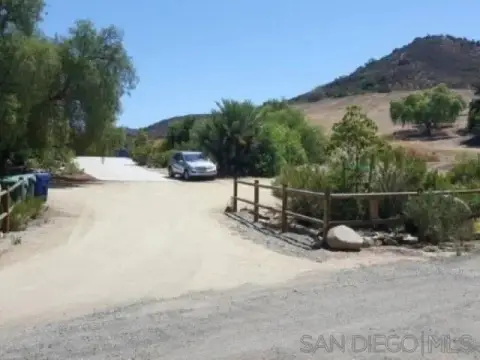
9340 Stevens Rd Santee, CA 92071-2810
Entity Owned
3-yr Hold
Absentee Owner
~
Est. High Equity
Property ID
US09-9401684
Property profile
Verified
Property type
Warehouses
Use group
WAREHOUSE, STORAGE
Year built
1987
Total area
14,946 SF
Lot
0.59 ac (25,700 SF)
Zoning code
INDUSTRIAL (M ZONE)
APN
381-640-25-00
UPID
US09-9401684
Cap rate & NOI
Priority signal for investors
Implied cap rate, NOI & suggested price
Cap rate vs submarket · NOI estimate · 3 price anchors
Implied cap rate, NOI & suggested price
Cap vs submarket · NOI estimate · 3 price anchors
Current use
Occupant on record · Public records
-
Birds Eye Aerial Drones Photography Service (Bike/Boat/Book/etc) Store
Value estimations
Realmo proprietary · 4 methods
AI Approach
AI
$5.38M
CAP Approach
CAP
$3.20M
Comparable Approach
Comparable
$5.32M
Blend (final)
Blend
$4.42M
Owner & transaction history
Tizdale LLC · 3 yrs held
Tizdale LLC
since 2023
Last sale
$4.2M
6 recorded transactions
Zoning & alternative use
INDUSTRIAL (M ZONE) · Santee, CA
Permitted uses
Permitted uses
Allowed · conditional · prohibited
Top alternative use upside
Medical building
$7.1M
+85.3%
Auto repair, garage
$5.7M
+49.1%
Office building
$5.4M
+40.6%
Cap rate
Implied · in-place · derived from last sale + estimated NOI
Implied Cap rate
#1
Implied · in-place · NOI ÷ last sale
In-place · derived from last sale + estimated NOI
Cap rate, NOI & submarket benchmark
Implied cap rate vs Santee submarket · NOI estimate · Typical band, median & reading
Implied cap rate, NOI & submarket benchmark
Cap vs Santee submarket · NOI estimate · typical band, median & reading
Refine your cap rate
8-question underwriting flow
1.
Property current status — Going-In vs Stabilized
2.
Price for denominator — asking / offer / market
3.
Leasing status & lease structure (NNN / Gross)
4.
Tenant risk profile & vacancy assumption
5.
Upload T12 / rent roll / OM (optional)
Refine in 60 seconds, get exact suggested price
T12 upload · Submarket benchmarks · Sensitivity grid
Suggested price · 3 cap rate anchors
Income approach @ 5% / 7% / 9% — aggressive / typical / conservative
Suggested price at 5% / 7% / 9% cap
Aggressive / typical / conservative · Implied $/SF per anchor · Sensitivity grid
Suggested price at 5% / 7% / 9% cap
Aggressive / typical / conservative · implied $/SF · sensitivity
Value
AI, CAP & Alternative Use estimations · Realmo proprietary blendValue Estimations
Based on Realmo’s proprietary methodology
AI Approach
Method
Estimation
Statistic approach
$5,325,000
ML approach
$5,375,000
CAP Approach
CAP Return
Estimation
6%
$3,460,000
6.5%
$3,195,000
7%
$2,965,000
Alternative Use
Use
Estimation
WAREHOUSE, STORAGE
$3,830,000
Current use
MEDICAL BUILDING
$7,095,000
Change: +85% · Conversion: Difficult
AUTO REPAIR, GARAGE
$5,705,000
Change: +49% · Conversion: Easy
OFFICE BUILDING
$5,385,000
Change: +41% · Conversion: Difficult
Blend value · Realmo final
$4.42M
Range $3.97M – $4.86M · ±10% · vs last sale $4.20M (Mar 1 2023)
Last sale anchor
$4.20M
Mar 1 2023
Realmo estimate · informational only.
These numbers are calculated by our models from public records and may not reflect actual market value.
Not an appraisal.
Verify with a licensed appraiser before transacting. Realmo accepts no liability for divergence from real-world outcomes.
View the full estimation — every method, every assumption
Confidence drivers & risk notes · Custom comparable set · Free for first 3 / day
Full estimation methodology
Every method · every assumption · confidence drivers
Price per SF
Sale + rent benchmarks
Subject property
$295 / SF
Submarket sale & rent benchmarks
Median sale $/SF · Asking & closed rent · Submarket vacancy
Submarket sale & rent benchmarks
Median sale $/SF · asking & closed rent · submarket vacancy
Property tax & assessments
Tax year 2024Property tax & assessments
Tax year 2024
Tax billed
$51,176
Tax year 2024
Assessed value
$4,284,000
Assessed 2024
Previous assessed
$4,284,000
+0.0% YoY
Effective rate
1.19%
On assessed value
Assessed land
$1,938,000
Assessed improvement
$2,346,000
Applied tax rate
16.0000
Comparables
6 recent transactions · within 1.5 miComparable in this city
6 recent transactions
Comparable in this City


Similar Nearby for Sale


Similar Nearby for Lease


Recent comparable sales
Sale price & price/SF · Sale date & distance · Adjustments & confidence
Recent comparable sales
Sale price & $/SF · sale date & distance · adjustments
Property description
Physical attributes from public recordsBuilding & lot
Public records
Property type
Warehouses
Use group
WAREHOUSE, STORAGE
Status
Off-Market
Year built
1987
Heating
NONE
Units
1
Total area
14,946 SF
Lot
0.59 ac (25,700 SF)
Zoning code
INDUSTRIAL (M ZONE)
APN
381-640-25-00
UPID
US09-9401684
Jurisdiction
SAN DIEGO
Zoning & alternative use
INDUSTRIAL (M ZONE) · Santee, CA
Zoning INDUSTRIAL (M ZONE) · permitted uses
INDUSTRIAL (M ZONE) · Santee, CA
Permitted & conditional uses
Allowed uses · Special-permit conditions · Prohibited uses
Permitted & conditional uses
Allowed · special-permit conditions · prohibited
Santee. Always verify with local authorities before improvements.
Alternative use value scenarios
Repositioning upside vs current use
WAREHOUSE, STORAGE Current
Est. value
$3.8M
MEDICAL BUILDING
Est. value
$7.1M
AUTO REPAIR, GARAGE
Est. value
$5.7M
OFFICE BUILDING
Est. value
$5.4M
WAREHOUSE, STORAGE Current
MEDICAL BUILDING
AUTO REPAIR, GARAGE
OFFICE BUILDING
Alternative use deep dive — conversion cost, permits, timeline
Conversion cost estimate · Permit path & risks · Stabilized NOI per option
Alternative use deep dive
Conversion cost · permit path · stabilized NOI per option
Building & site characteristics
From public records
Year built
1987
Heating
NONE
Units
1
Lot
0.59 ac
Current owner
From public records · entity-resolved
Tizdale LLC
Entity
Mailing address
3688 MIDWAY DR, SAN DIEGO, CA 92110-5201
Mailing matches property
Different — outreach signal
Owner-occupied
No
Ownership since
2023
Owner contacts — direct phone, email, and related entities
Decision-maker phone · Verified email · Related entities & filings
Owner contacts
Email · phone · related entities
Sales History
6 recorded events · public records
Date
Price
Buyer
Seller
Deed Type
Mortgage
Mar 1, 2023
$4,200,000
Tizdale LLC
Hanson Holdings INC
Grant Deed
$3,700,000 · Hanson Holdings INC
Apr 23, 1999
$685,000
Hanson Holdings
Shteremberg,bernardo
Grant Deed
related
$952,000 · Union Bank Of California
Jan 28, 1999
—
Bernardo Shteremberg
Shteremberg,sara
Quit Claim Deed
related
—
—
—
Hanson Holdings INC
—
Loan Modification
related
$200,000 · California Bank & Trust
—
—
Bernardo Shteremberg
—
Deed Of Trust
related
$225,000 · Ruth Litt Trustee
—
—
Hanson Holdings INC
—
Deed Of Trust
related
$800,000 · California Bank & Trust
Coming soon
Costs & Benchmarks
Operating expenses, capex projections, utility benchmarks, and submarket comparables — all in one view.
Coming soon
Risks
Flood, climate, environmental, title, and tenant-concentration risk — surfaced with mitigations and source citations.
Try Rey
Ask anything about this address in plain English.
“Is 15.6% cap rate sustainable?” · “Best tenant mix for BU1?” · “What’s the redev upside?”
You own 9340 Stevens Rd?
List it free. Reach 20,000 daily buyers.
We’ve already pulled the facts. Confirm photos + price and you’re live in 2 minutes.
List this address →
Full reports are paid
Unlock the full Property Analytics report
Start free for 7 days — no card required. Full owner contacts, all 4 valuations with methodology, refine flow, comparable adjustments, foot-traffic deep dive, export to PDF / CSV.


