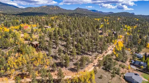
815 Burland Dr Bailey, CO 80421
Own a piece of Colorado history with this exceptional 34.12-acre property, situated atop Mount Bailey at an elevation of 9,089 feet. This unique offering includes the 1944 U.S. Geological Survey monument. Enjoy breathtaking, panoramic views encompassing Lone Rock, Lions Head, Rosalie Peak (13,575 ft), Mount Logan (12,870 ft), and Crooked Top Mountain. The west half of Mount Bailey is yours, with the east half comprising Weakland-Fawks Park, accessible via a hiking trail. While not part of the Burland HOA, the option to join as a non-voting member exists. A pre-built driveway leads to a cleared building site approximately one-third up the mountain, offering expansive northern views. A second potential building site is located further up the mountain, with old deer trails leading to the summit and 270-degree views. The property features a septic system installed for a three-bedroom home. Utilities include readily available electricity and natural gas at the street. Note that a well will need to be drilled for household use only. While the property narrows at the summit, it widens on the south side, extending down the slope overlooking Pike National Forest. Please be aware of cliffs and wildlife on the mountain. The asking price is $498,000, and the property is offered as a fee simple ownership. Access requires prior arrangement.
Cap rate
Implied · in-place · derived from last sale + estimated NOIValue
AI, CAP & Alternative Use estimations · Realmo proprietary blendComparables
6 recent transactions · within 1.5 miComparable in this City


Similar Nearby for Sale
Property description
Physical attributes from public recordsZoning & alternative use
No recorded transactions found for this property.
Costs & Benchmarks
Operating expenses, capex projections, utility benchmarks, and submarket comparables — all in one view.
Risks
Flood, climate, environmental, title, and tenant-concentration risk — surfaced with mitigations and source citations.


