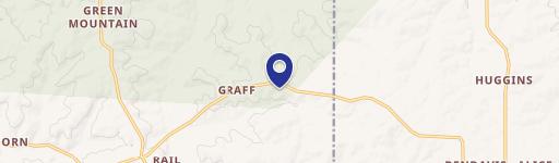
7910 Murr Rd Graff, MO 65660-9358
Property profile & analytics
7910 Murr Rd, Graff, MO 65660-9358
- Commercial land
- 4.01 lot acres
Property ID
US48-3191176
The Realmo ID is a unique identifier assigned to every property, incorporating country codes and precise geo-coordinates for 300x300-foot land blocks. It enables standardized data collection and seamless integration of disparate sources such as ownership, tax, title data and physical specifications. By aggregating current and historical records, the Realmo ID powers advanced analytics and delivers deep, verifiable insights for real estate professionals.
Location Intelligence
Current Use by Public Records
- Commercial land
Property Details for 7910 Murr Rd
- Lot size
- 4.01 lot acres
- Property type
- Commercial land
- APN
- 11-2.0-04-0-000-003.01
- APU
- 112004000000301
Sales History
| Date | Price | Buyer | Seller | Deed Type | Mortgage |
|---|---|---|---|---|---|
| Jun 27, 2024 | — | John Wade | — | Deed · related | $325k · Town & Country Bank |
| Aug 18, 2023 | — | John Wade | Samantha Wade | Intrafamily Transfer · related | $50k · Town & Country Bank |
Value Estimations
based on Realmo’s proprietary methodology
-
AI approach
-
CAP approach
-
Comparable approach
-
Alternative Use
Get a detailed, property-specific estimation — fast and free
Location Insight
- Map
- Local Demand
- City
- Graff
- County
- Wright
- State
- Missouri
- Longitude
- -92.263
- Latitude
- 37.3403
Property Tax & Assessments
Tax date
Tax Amount
Assessed Land Value
Assessed Improvement Value
Total Assessed Value
Applied Tax Rate
Land Market Value
Improvement Market Value
Total Market Value
0
$0.00
$0.00
$0.00
$8,450
-
$0.00
$0.00
$0.00