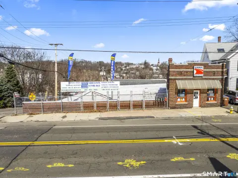
79 Platt Rd Shelton, CT 06484-5338
Property profile & analytics
79 Platt Rd, Shelton, CT 06484-5338
- Industrial land
- 1,330 SF
- 1.96 lot acres
Property ID
US15-0978527
The Realmo ID is a unique identifier assigned to every property, incorporating country codes and precise geo-coordinates for 300x300-foot land blocks. It enables standardized data collection and seamless integration of disparate sources such as ownership, tax, title data and physical specifications. By aggregating current and historical records, the Realmo ID powers advanced analytics and delivers deep, verifiable insights for real estate professionals.
Location Intelligence
Current Use by Public Records
- Industrial land
Property Details for 79 Platt Rd
- Year built
- 1958
- Construction
- WOOD FRAME
- Lot size
- 1.96 lot acres
- Zone code
- IA-2
- Property type
- Industrial land
- APN
- SHEL M:77 L:20
- APU
- SHELM77L20
Sales History
| Date | Price | Buyer | Seller | Deed Type | Mortgage |
|---|---|---|---|---|---|
| Dec 14, 2023 | — | 79 Platt Road LLC | — | Deed · related | $120k · Thomaston Savings Bank |
| Oct 11, 2019 | — | 79 Platt Rd LLC | John Mandanici | Quit Claim Deed · related | — |
| Mar 20, 2018 | $409,000 | Eileen Mandacini | Kassheimer Charles | Executors Deed | — |
Value Estimations
based on Realmo’s proprietary methodology
-
AI approach
-
CAP approach
-
Comparable approach
-
Alternative Use
Get a detailed, property-specific estimation — fast and free
Location Insight
- Map
- Local Demand
- City
- Shelton
- County
- Fairfield
- State
- Connecticut
- Longitude
- -73.107
- Latitude
- 41.295
- CBSA code
- 14860
- CBSA name
- BRIDGEPORT-STAMFORD-NORWALK, CT METROPOLITAN STATISTICAL AREA
Property Tax & Assessments
Tax date
Tax Amount
Assessed Land Value
Assessed Improvement Value
Total Assessed Value
Applied Tax Rate
Land Market Value
Improvement Market Value
Total Market Value
2023
$3,188
$182,490
$0.00
$182,490
-
$0.00
$0.00
$0.00