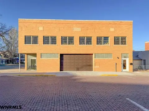
750 7th St Alliance, NE 69301-3541
Property profile & analytics
750 7th St, Alliance, NE 69301-3541
- Commercial real estate
- 2,256 SF
- 0.34 lot acres
Property ID
US57-0342731
The Realmo ID is a unique identifier assigned to every property, incorporating country codes and precise geo-coordinates for 300x300-foot land blocks. It enables standardized data collection and seamless integration of disparate sources such as ownership, tax, title data and physical specifications. By aggregating current and historical records, the Realmo ID powers advanced analytics and delivers deep, verifiable insights for real estate professionals.
Location Intelligence
Current Use by Public Records
- Commercial real estate
Property Details for 750 7th St
- Year built
- 1948
- Lot size
- 0.34 lot acres
- Zone code
- 02-MULTI-FAMILY
- Property type
- Commercial real estate
- APN
- 70007381
- APU
- 70007381
Sales History
| Date | Price | Buyer | Seller | Deed Type | Mortgage |
|---|---|---|---|---|---|
| Mar 25, 2013 | — | Garry Rasmussen | Fannie Mae | Special Warranty Deed | — |
| Jan 11, 2013 | — | Federal National Mortgage Associati | Jpmorgan Chase Bank | Special Warranty Deed | — |
Value Estimations
based on Realmo’s proprietary methodology
-
AI approach
-
CAP approach
-
Comparable approach
-
Alternative Use
Get a detailed, property-specific estimation — fast and free
Location Insight
- Map
- Local Demand
- City
- Alliance
- County
- Box Butte
- State
- Nebraska
- Longitude
- -102.859
- Latitude
- 42.1017
Property Tax & Assessments
Tax date
Tax Amount
Assessed Land Value
Assessed Improvement Value
Total Assessed Value
Applied Tax Rate
Land Market Value
Improvement Market Value
Total Market Value
2023
$1,207
$11,160
$59,040
$70,200
-
$11,160
$59,040
$70,200