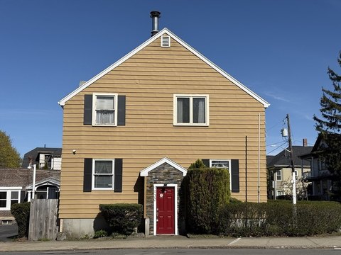
75-77 Tarkiln Hl Rd New Bedford, MA 02745
Property profile & analytics
75-77 Tarkiln Hl Rd, New Bedford, MA 02745
- Investment properties
- 12,721 SF
- 0.13 lot acres
Property ID
US38-1240049
The Realmo ID is a unique identifier assigned to every property, incorporating country codes and precise geo-coordinates for 300x300-foot land blocks. It enables standardized data collection and seamless integration of disparate sources such as ownership, tax, title data and physical specifications. By aggregating current and historical records, the Realmo ID powers advanced analytics and delivers deep, verifiable insights for real estate professionals.
Location Intelligence
Current Use by Public Records
- Investment properties
Property Details for 75-77 Tarkiln Hl Rd
- Year built
- 1920
- Construction
- FRAME
- Lot size
- 0.13 lot acres
- Zone code
- MUB
- Property type
- Investment properties
- Property subtype
- Live-work space
- APN
- NEWB M:0119 L:0124
- APU
- NEWBM0119L0124
Sales History
| Date | Price | Buyer | Seller | Deed Type | Mortgage |
|---|---|---|---|---|---|
| Jul 18, 2008 | — | Tarkiln Hill T 77 | — | Deed Of Trust · related | $250k · Wells Fargo Mortgage |
Value Estimations
based on Realmo’s proprietary methodology
-
Comparable approach
- Method
- Estimation
- Statistic Estimate
- $849,000
- AI Estimate
- $798,000
Market price range: $850k - $2.07MMarket price range: $798k - $1.97M
Get a detailed, property-specific estimation — fast and free
Location Insight
- Map
- Local Demand
- City
- New Bedford
- County
- Bristol
- State
- Massachusetts
- Longitude
- -70.9216
- Latitude
- 41.6821
- CBSA code
- 39300
- CBSA name
- PROVIDENCE-NEW BEDFORD-FALL RIVER, RI-MA METROPOLITAN STATISTICAL AREA
Property Tax & Assessments
Tax date
Tax Amount
Assessed Land Value
Assessed Improvement Value
Total Assessed Value
Applied Tax Rate
Land Market Value
Improvement Market Value
Total Market Value
2024
$0.00
$164,700
$588,800
$753,500
-
$0.00
$0.00
$0.00