7010 Hwy 71 Austin, TX 78735-8300
Property profile & analytics
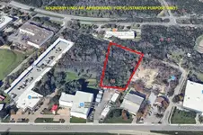
7010 Hwy 71, Austin, TX 78735-8300
- Strip malls
- 37,016 SF
- 11.91 lot acres
Property ID
US82-4259209
The Realmo ID is a unique identifier assigned to every property, incorporating country codes and precise geo-coordinates for 300x300-foot land blocks. It enables standardized data collection and seamless integration of disparate sources such as ownership, tax, title data and physical specifications. By aggregating current and historical records, the Realmo ID powers advanced analytics and delivers deep, verifiable insights for real estate professionals.
Location Intelligence
Current Use by Public Records
- H-E-B Pharmacy / Pharmacy
- higi / Physician
Property Details for 7010 Hwy 71
- Year built
- 1985
- Construction
- CONCRETE
- Lot size
- 11.91 lot acres
- Property type
- Strip malls
- Property subtype
- Shopping centers
- APN
- 408380202
- APU
- 408380202
Sales History
| Date | Price | Buyer | Seller | Deed Type | Mortgage |
|---|---|---|---|---|---|
| Jul 1, 2009 | — | Kimco Austin | — | Deed Of Trust · related | $108.4M · Prudential Insurance Co |
| Mar 18, 1985 | — | Center Hill Joint & Venture | — | Warranty Deed · related | — |
Value Estimations
based on Realmo’s proprietary methodology
-
Alternative Use
- Use
- Estimation
- NEIGHBORHOOD: SHOPPING CENTER
- $1,265,000 Current use
- WAREHOUSE, STORAGE
- $1,485,000 Change: +17% Conversion: Difficult
Get a detailed, property-specific estimation — fast and free
Location Insight
- Map
- Local Demand
- City
- Austin
- County
- Travis
- State
- Texas
- Longitude
- -97.8747
- Latitude
- 30.2353
- CBSA code
- 12420
- CBSA name
- AUSTIN-ROUND ROCK, TX METROPOLITAN STATISTICAL AREA
Property Tax & Assessments
Tax date
Tax Amount
Assessed Land Value
Assessed Improvement Value
Total Assessed Value
Applied Tax Rate
Land Market Value
Improvement Market Value
Total Market Value
2022
$363,594
$10,374,240
$3,476,754
$13,850,994
-
$10,374,240
$3,476,754
$13,850,994