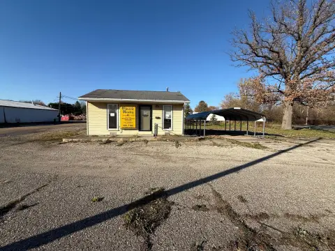
69573 Sunset Blvd Union, MI 49130-8724
Property profile & analytics
69573 Sunset Blvd, Union, MI 49130-8724
- Commercial real estate
- 0.31 lot acres
Property ID
US43-2243829
The Realmo ID is a unique identifier assigned to every property, incorporating country codes and precise geo-coordinates for 300x300-foot land blocks. It enables standardized data collection and seamless integration of disparate sources such as ownership, tax, title data and physical specifications. By aggregating current and historical records, the Realmo ID powers advanced analytics and delivers deep, verifiable insights for real estate professionals.
Location Intelligence
Current Use by Public Records
- Commercial real estate
Property Details for 69573 Sunset Blvd
- Lot size
- 0.31 lot acres
- Property type
- Commercial real estate
- APN
- 14-120-209-020-00
- APU
- 1412020902000
Sales History
| Date | Price | Buyer | Seller | Deed Type | Mortgage |
|---|---|---|---|---|---|
| Jun 3, 2016 | $115,000 | Capital Plaza LLC | M & M Property Control LLC | Warranty Deed | $96k · Old National Bank |
| Apr 18, 2008 | — | M & M Property Control LLC | Michael C Waumans SR. | Quit Claim Deed · related | — |
| Aug 31, 2005 | $60,000 | Michael C Waumans SR. | Curtis Kehr | Warranty Deed | $80k · Elkhart Community Bank |
Value Estimations
based on Realmo’s proprietary methodology
-
AI approach
-
CAP approach
-
Comparable approach
-
Alternative Use
Get a detailed, property-specific estimation — fast and free
Location Insight
- Map
- Local Demand
- City
- Union
- County
- Cass
- State
- Michigan
- Longitude
- -85.8222
- Latitude
- 41.7865
- CBSA code
- 43780
- CBSA name
- SOUTH BEND-MISHAWAKA, IN-MI METROPOLITAN STATISTICAL AREA
Property Tax & Assessments
Tax date
Tax Amount
Assessed Land Value
Assessed Improvement Value
Total Assessed Value
Applied Tax Rate
Land Market Value
Improvement Market Value
Total Market Value
2022
$2,377
$0.00
$0.00
$69,100
-
$0.00
$0.00
$138,200