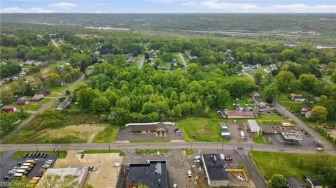
685 Mccartney Rd Campbell, OH 44405
Property profile & analytics
685 Mccartney Rd, Campbell, OH 44405
- Drive through restaurants
- 3,634 SF
- 0.37 lot acres
Property ID
US66-2349974
The Realmo ID is a unique identifier assigned to every property, incorporating country codes and precise geo-coordinates for 300x300-foot land blocks. It enables standardized data collection and seamless integration of disparate sources such as ownership, tax, title data and physical specifications. By aggregating current and historical records, the Realmo ID powers advanced analytics and delivers deep, verifiable insights for real estate professionals.
Location Intelligence
Current Use by Public Records
- Drive through restaurants
Property Details for 685 Mccartney Rd
- Year built
- 1987
- Lot size
- 0.37 lot acres
- Property type
- Drive through restaurants
- APN
- 46-011-0-237.00-0
- APU
- 460110237000
Sales History
| Date | Price | Buyer | Seller | Deed Type | Mortgage |
|---|---|---|---|---|---|
| Nov 26, 2013 | $1,673,500 | Arc Bkmst41001 LLC | Toms King Re Ohio LLC | Limited Warranty Deed | — |
| Apr 25, 2012 | — | Toms King Re Ohio LLC | Pmsre LLC | Limited Warranty Deed | — |
| Jan 27, 2012 | — | Pmsre LLC | Srep Land LLC | Limited Warranty Deed | — |
| Mar 22, 2010 | — | Srep Land LLC | William R Spence JR | Quit Claim Deed · related | — |
Value Estimations
based on Realmo’s proprietary methodology
-
AI approach
-
CAP approach
-
Comparable approach
-
Alternative Use
Get a detailed, property-specific estimation — fast and free
Location Insight
- Map
- Local Demand
- City
- Campbell
- County
- Mahoning
- State
- Ohio
- Longitude
- -80.5916
- Latitude
- 41.09
- CBSA code
- 49660
- CBSA name
- YOUNGSTOWN-WARREN-BOARDMAN, OH-PA METROPOLITAN STATISTICAL AREA
Property Tax & Assessments
Tax date
Tax Amount
Assessed Land Value
Assessed Improvement Value
Total Assessed Value
Applied Tax Rate
Land Market Value
Improvement Market Value
Total Market Value
2023
$12,763
$22,330
$178,550
$200,880
-
$63,800
$510,130
$573,930