6460 NW Beaver Dr Johnston, IA 50131
 For Lease
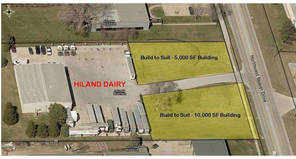
This exceptional industrial property, located at 6460 NW Beaver Drive in Johnston, Iowa (zip code 50131), offers a total of 15,000 square feet of warehouse and distribution space. The property sits on a generous 2.4-acre lot and is zoned M-1, providing ample opportunity for various industrial uses. The building is currently fully vacant and available for immediate occupancy. Multiple tenancy options are available, with spaces divisible to a minimum of 5,000 square feet and a maximum contiguous space of 10,000 square feet. This presents a unique opportunity for businesses seeking flexible space to accommodate their specific needs. The property's location in Polk County, Iowa, offers convenient access to major transportation routes, enhancing logistical efficiency. The site is strategically positioned east of Hiland Dairy, providing excellent visibility and accessibility. The property is ideally suited for build-to-suit opportunities, allowing for customized development to meet individual business requirements. The northern portion of the lot can accommodate a building up to 5,000 square feet, while the southern portion allows for a building up to 10,000 square feet. This versatile property is an excellent investment opportunity for businesses seeking a prime location in a thriving industrial area.
6. Light Industrial District. The intent of the M-1 District is to provide areas of the City suitable for light industrial uses such as assembly, fabrication, and processing of goods and materials, where industrial activities are conducted primarily within buildings and where the byproducts of industrial activities, such as noise, odors, smoke, and storage a…
Cap rate
Implied · in-place · derived from last sale + estimated NOIValue
AI, CAP & Alternative Use estimations · Realmo proprietary blendProperty tax & assessments
Tax year 2020Comparables
6 recent transactions · within 1.5 miComparable in this City


Similar Nearby for Sale




Similar Nearby for Lease


Property description
Physical attributes from public recordsZoning & alternative use
M-1 · Johnston, IA6. Light Industrial District. The intent of the M-1 District is to provide areas of the City suitable for light industrial uses such as assembly, fabrication, and processing of goods and materials, where industrial activities are conducted primarily within buildings and where the byproducts of industrial activities, such as noise, odors, smoke, and storage are generally confined within buildings and ordinarily do not have nuisance impacts on surrounding properties. 7. General Industrial District. The intent of the M-2 District is to provide areas of the City suitable for moderate to heavy industrial uses such as manufacturing, assembly, processing, warehousing, and distribution which generally require larger land areas, significant exterior operation or storage of equipment and materials, and/or where the byproducts of industrial activities, such as noise, odors, smoke, and storage, may have nuisance impacts on surrounding properties. 169.03 USE REGULATIONS 1. General Provisions A. When a property is located within the boundaries of one (1) or more overlay districts, the most restrictive use provision among the overlay and base zoning districts shall apply. B. All uses are subject to any other applicable provision of this Zoning Ordinance and any other chapter of this Code of Ordinances including but not limited to the following: 1. Off-Street Parking and Loading. See Chapter 180. 2. Landscaping and Open Space requirements. See Chapter 181. 3. Buffer requirements. See Chapter 182. 4. Architectural standards. See Chapter 185. 5. Sign regulations. See Chapter 187. 6. Site Plan requirements. See Chapter 190. 2. Use Tables A. Table 169.1 Principal Uses and Table 169.2 Accessory Uses list land uses and indicate whether they are permitted, permitted with standards, permitted with Site Plan Review, special, temporary, or prohibited in each zoning district. The tables also include references to whether additional use specific standards are applicable to that use. The following definitions shall be referenced when using Tables 169.1 and 169.2: 1. Permitted Use - a “P” in a cell of the use table indicates that the land use is allowed by right in the zoning district. City of Johnston Zoning and Subdivision Update Last Updated: March 31, 2023
Costs & Benchmarks
Operating expenses, capex projections, utility benchmarks, and submarket comparables — all in one view.
Risks
Flood, climate, environmental, title, and tenant-concentration risk — surfaced with mitigations and source citations.


