622 Rte 213 Rosendale, NY 12472
Such buildings may be located in the required side or rear yard in the A, A-1 and R-1 Districts at a minimum of 10 feet from any rear or side lot line. (b) Such buildings may be located in the required rear or side yard in the R-2, R-2a and R-3 Districts at a minimum of five feet from any rear or side lot line. (c) Such building, except for agricultural purp…
Cap rate
Implied · in-place · derived from last sale + estimated NOIValue
AI, CAP & Alternative Use estimations · Realmo proprietary blendProperty tax & assessments
Comparables
6 recent transactions · within 1.5 miComparable in this City


Similar Nearby for Sale

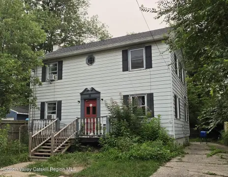

Property description
Physical attributes from public recordsZoning & alternative use
R-1 · Rosendale, NYSuch buildings may be located in the required side or rear yard in the A, A-1 and R-1 Districts at a minimum of 10 feet from any rear or side lot line. (b) Such buildings may be located in the required rear or side yard in the R-2, R-2a and R-3 Districts at a minimum of five feet from any rear or side lot line. (c) Such building, except for agricultural purposes, shall not exceed the maximum height permitted in the district in which it is located, or a maximum floor area of more than 500 square feet. (d) Such building, together with all other buildings on the lot, shall not occupy more than the permitted lot coverage in the district in which it is located. (e) Such building shall be located no closer to the principal building than 12 feet or the height of the accessory building, whichever is greater. (3) Accessory uses not enclosed in a building, such as but not limited to swimming pools and tennis courts, may be permitted in a required side or rear yard in the A, A-1 and R-1 Districts not closer than 20 feet from a rear or side lot line and may be permitted in a required rear or side yard in the R-2, R-2a and R-3 Districts not closer than 10 feet to either a rear or side yard line. (4) Any swimming or ornamental pool with a depth greater than 18 inches and a surface area of more than 150 square feet shall only be permitted subject to the issuance of a building permit. Swimming pools shall be protected by a permanent fence or barrier designed and maintained to prevent accidental entry or unauthorized use of the pool. Such fence shall be at least four feet high and completely enclose either the pool or that portion of the property in which the pool is situated or the entire property. All openings in said fence shall have a self-closing gate or door with adequate lock to ensure that such gate or door remains closed and locked at all times when the pool is not in use. The design and construction of the fence or barrier shall be approved by the Building Inspector at the time of issuance of a building permit. If all parts of the pool are elevated above the adjacent grade by a perpendicular wall at least four feet in height, a fence or barrier is not required, provided that all points of access to the pool are protected by self-locking gates or removable ladders. The provisions of this subsection shall apply to new pools immediately and, to pools existing on the date of adoption of this subsection, it shall apply as of April 15, 1984. F. Corner clearance.
No recorded transactions found for this property.
Costs & Benchmarks
Operating expenses, capex projections, utility benchmarks, and submarket comparables — all in one view.
Risks
Flood, climate, environmental, title, and tenant-concentration risk — surfaced with mitigations and source citations.


