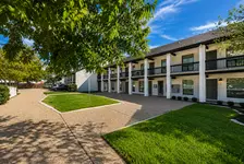
6201 Hwy 290 Austin, TX 78723-1025
Property profile & analytics
6201 Hwy 290, Austin, TX 78723-1025
- Motels
- 22,410 SF
- 1.64 lot acres
Property ID
US83-4151607
The Realmo ID is a unique identifier assigned to every property, incorporating country codes and precise geo-coordinates for 300x300-foot land blocks. It enables standardized data collection and seamless integration of disparate sources such as ownership, tax, title data and physical specifications. By aggregating current and historical records, the Realmo ID powers advanced analytics and delivers deep, verifiable insights for real estate professionals.
Location Intelligence
Current Use by Public Records
- Motels
Property Details for 6201 Hwy 290
- Year built
- 1963
- Lot size
- 1.64 lot acres
- Property type
- Motels
- APN
- 225150330
- APU
- 225150330
Sales History
| Date | Price | Buyer | Seller | Deed Type | Mortgage |
|---|---|---|---|---|---|
| Sep 9, 2021 | — | Emerald Hotel LLC | Rose Hotel LLC | Warranty Deed | $2.9M · Lone Star National Bank |
| Aug 6, 2015 | — | Rose Hotel LLC | Austin Lodging LLC | Warranty Deed | $2.8M · Royal Busn Bk |
| Jul 25, 2012 | — | Austin Lodging LLC | 290 Hotel LLC | Grant Deed | — |
| May 11, 2012 | $442,001 | 290 Hotel LLC | Strickland Juanita | Trustees Deed · related | — |
| May 3, 2012 | — | 290 Hotel LLC | — | Trustees Deed · related | $500k · Yellow Tulip LLC |
| — | — | Austin Lodging LLC | — | Deed Of Trust · related | $1.1M · Piyush P & Nimesh R Patel |
Value Estimations
based on Realmo’s proprietary methodology
-
AI approach
-
CAP approach
-
Comparable approach
-
Alternative Use
Get a detailed, property-specific estimation — fast and free
Location Insight
- Map
- Local Demand
- City
- Austin
- County
- Travis
- State
- Texas
- Longitude
- -97.7026
- Latitude
- 30.3214
- CBSA code
- 12420
- CBSA name
- AUSTIN-ROUND ROCK, TX METROPOLITAN STATISTICAL AREA
Property Tax & Assessments
Tax date
Tax Amount
Assessed Land Value
Assessed Improvement Value
Total Assessed Value
Applied Tax Rate
Land Market Value
Improvement Market Value
Total Market Value
2022
$47,793
$2,149,710
$473,492
$2,623,202
-
$2,149,710
$473,492
$2,623,202