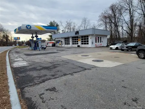
563 Rte 312 Brewster, NY 10509-3718
R20 District (Residential). A. Allowed uses. Within any R20 District, no building, structure, lot or land shall be used for any purpose other than the following and their normal and customary accessory uses, except as provided in Subsections B and C : (1) Single-family dwellings, either detached, semidetached or attached. (2) Cluster. B. Allowed accessory us…
Cap rate
Implied · in-place · derived from last sale + estimated NOIValue
AI, CAP & Alternative Use estimations · Realmo proprietary blendProperty tax & assessments
Tax year 2020Comparables
6 recent transactions · within 1.5 miComparable in this City


Similar Nearby for Sale


Similar Nearby for Lease


Property description
Physical attributes from public recordsZoning & alternative use
R20 · Brewster, NYR20 District (Residential). A. Allowed uses. Within any R20 District, no building, structure, lot or land shall be used for any purpose other than the following and their normal and customary accessory uses, except as provided in Subsections B and C : (1) Single-family dwellings, either detached, semidetached or attached. (2) Cluster. B. Allowed accessory uses. Within any R20 District, the following accessory uses shall be allowed: (1) Private garages or private parking areas providing a minimum of two parking spaces pursuant to § 263-18 . (2) Home occupation/professional offices. C. Special exception uses. Within any R20 District, the following special exception uses shall be allowed, subject to the requirements of § 263-20 : (1) Bed-and-breakfast. D. Height. No building or other structure shall exceed a height of 35 feet or 2 1/2 stories plus basement, whichever is less. E. Lot and yard requirements. Within any R20 District, no building or structure shall be erected nor any lot or land area developed unless in conformity with the following requirements: Requirement Measurement Minimum lot area 20,000 square feet Minimum lot width 100 feet Maximum lot coverage 15% Open space requirement 5,000 square feet per dwelling unit Minimum yards: Front depth 25 feet One side width 20 feet Both sides total width 40 feet Side yard abutting a street on corner lot, width 25 feet Rear depth 40 feet F.
Costs & Benchmarks
Operating expenses, capex projections, utility benchmarks, and submarket comparables — all in one view.
Risks
Flood, climate, environmental, title, and tenant-concentration risk — surfaced with mitigations and source citations.


