520 Polaris Pkwy Westerville, OH 43082-7044
Property profile & analytics
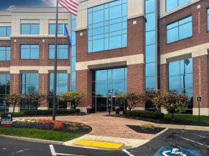
520 Polaris Pkwy, Westerville, OH 43082-7044
- Banks
- 14,032 SF
- 1.85 lot acres
Property ID
US66-6066232
The Realmo ID is a unique identifier assigned to every property, incorporating country codes and precise geo-coordinates for 300x300-foot land blocks. It enables standardized data collection and seamless integration of disparate sources such as ownership, tax, title data and physical specifications. By aggregating current and historical records, the Realmo ID powers advanced analytics and delivers deep, verifiable insights for real estate professionals.
Location Intelligence
Current Use by Public Records
- ATM (Key Bank) / Atm
- KeyBank / Bank / Loan Service
Property Details for 520 Polaris Pkwy
- Year built
- 2004
- Lot size
- 1.85 lot acres
- Property type
- Banks
- APN
- 318-441-01-003-003
- APU
- 31844101003003
Sales History
| Date | Price | Buyer | Seller | Deed Type | Mortgage |
|---|---|---|---|---|---|
| Dec 15, 2017 | — | Shops At Westar LLC | Shops At Westar Ccc LLC | Quit Claim Deed · related | $3.7M · Park Nat'l Bk |
| Dec 29, 2005 | — | Shops At Westar Ccc LLC | Columbus Corporate Center INC | Warranty Deed | $3M · Key Bank NA |
| — | — | Shops At Westar Ccc LLC | — | Deed Of Trust · related | $2.7M · Fcbank |
| — | — | Shops At Westar LLC | — | Deed Of Trust · related | $3.5M · First Fed'l Bk/the Midwest |
| — | — | Jag Guru LLC | — | Deed Of Trust · related | $3.7M · Park Nat'l Bk |
| — | — | Sat Guru LLC | — | Deed Of Trust · related | $3.7M · Park Nat'l Bk |
Value Estimations
based on Realmo’s proprietary methodology
-
Alternative Use
- Use
- Estimation
- APARTMENT HOUSE (5+ UNITS)
- $1,090,000
Get a detailed, property-specific estimation — fast and free
Location Insight
- Map
- Local Demand
- City
- Westerville
- County
- Delaware
- State
- Ohio
- Longitude
- -82.9472
- Latitude
- 40.1464
- CBSA code
- 18140
- CBSA name
- COLUMBUS, OH METROPOLITAN STATISTICAL AREA
Property Tax & Assessments
Tax date
Tax Amount
Assessed Land Value
Assessed Improvement Value
Total Assessed Value
Applied Tax Rate
Land Market Value
Improvement Market Value
Total Market Value
2023
$90,805
$422,170
$697,900
$1,120,070
-
$1,206,200
$1,994,000
$3,200,200