47 Stowe Rd, Millbury, MA 01527
- Commercial real estate
Current Use by Public Records
- Commercial real estate
Property Details for 47 Stowe Rd
- Property type
- Commercial real estate
Description
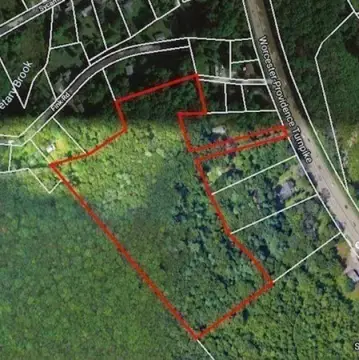
This exceptional ±29-acre property, located at 47 Stowe Road in West Millbury, Massachusetts, presents a unique opportunity for residential development. Situated in a tranquil country setting, the land boasts beautiful surroundings and picturesque views. The existing zoning and lot size regulations may allow for the creation of approximately 14-15 single-family home lots, making this an ideal site for a new subdivision. The property's peaceful atmosphere is complemented by its strategic location, offering convenient access to major transportation arteries. These include Routes 20 and 146, as well as Interstates 290, 395, and the Massachusetts Turnpike (Mass Pike). This combination of serene surroundings and excellent accessibility makes 47 Stowe Road a highly desirable location for residential development. The asking price for this expansive parcel is $1,600,000. Detailed information regarding zoning regulations and potential development plans is available upon request. This is a rare opportunity to acquire a substantial land parcel with significant development potential in a highly sought-after area of Massachusetts. The property is classified as residential land and is located in Worcester County, with a zip code of 01527. The coordinates are 42.181386 latitude and -71.8107799 longitude.
Value Estimations
-
AI approach
-
CAP approach
-
Comparable approach
-
Alternative Use
Get a detailed, property-specific estimation — fast and free
Location Insight
- Map
- Local Demand
- City
- Millbury
- County
- Worcester
- State
- Massachusetts
- Longitude
- -71.8107799
- Latitude
- 42.181386