
New search
Property profile & analytics
OFF-MARKET
Grocery and convenience stores
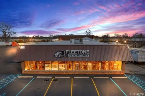
34243 Palmer Rd, Westland, MI 48186-4680
Entity Owned
5-yr Hold
Absentee Owner
Free & Clear
Property ID
US43-1587560
Property profile
Verified
Property type
Grocery and convenience stores
Use group
CONVENIENCE STORE
Year built
1971
Total area
2,400 SF
Lot
0.28 ac (12,197 SF)
APN
56 074 06 1213 004
UPID
US43-1587560
Cap rate & NOI
Priority signal for investors
Implied cap rate, NOI & suggested price
Cap rate vs submarket · NOI estimate · 3 price anchors
Implied cap rate, NOI & suggested price
Cap vs submarket · NOI estimate · 3 price anchors
Current use
Occupant on record · Public records
-
ATM Atm
Value estimations
Realmo proprietary · 4 methods
AI Approach
AI
by Request
CAP Approach
CAP
by Request
Comparable Approach
Comparable
by Request
Blend (final)
Blend
by Request
Owner & transaction history
Snm Yono Properties LLC · 5 yrs held
Snm Yono Properties LLC
since 2021
Last sale
$125,000
2 recorded transactions
Zoning & alternative use
Permitted uses
Permitted uses
Allowed · conditional · prohibited
Cap rate
Implied · in-place · derived from last sale + estimated NOI
Implied Cap rate
#1
Implied · in-place · NOI ÷ last sale
In-place · derived from last sale + estimated NOI
Cap rate, NOI & submarket benchmark
Implied cap rate vs Westland submarket · NOI estimate · Typical band, median & reading
Implied cap rate, NOI & submarket benchmark
Cap vs Westland submarket · NOI estimate · typical band, median & reading
Refine your cap rate
8-question underwriting flow
1.
Property current status — Going-In vs Stabilized
2.
Price for denominator — asking / offer / market
3.
Leasing status & lease structure (NNN / Gross)
4.
Tenant risk profile & vacancy assumption
5.
Upload T12 / rent roll / OM (optional)
Refine in 60 seconds, get exact suggested price
T12 upload · Submarket benchmarks · Sensitivity grid
Suggested price · 3 cap rate anchors
Income approach @ 5% / 7% / 9% — aggressive / typical / conservative
Suggested price at 5% / 7% / 9% cap
Aggressive / typical / conservative · Implied $/SF per anchor · Sensitivity grid
Suggested price at 5% / 7% / 9% cap
Aggressive / typical / conservative · implied $/SF · sensitivity
Value
AI, CAP & Alternative Use estimations · Realmo proprietary blendValue Estimations
Based on Realmo’s proprietary methodology
AI Approach
CAP Approach
Comparable Approach
Alternative Use
Get a detailed, property-specific estimation — fast and free
Price per SF
Sale + rent benchmarks
Subject property
—
Submarket sale & rent benchmarks
Median sale $/SF · Asking & closed rent · Submarket vacancy
Submarket sale & rent benchmarks
Median sale $/SF · asking & closed rent · submarket vacancy
Property tax & assessments
Tax year 2023Property tax & assessments
Tax year 2023
Tax billed
$6,897
Tax year 2023
Assessed value
$119,200
Assessed 2024
Previous assessed
$107,200
+11.2% YoY
Effective rate
5.79%
On assessed value
Total market value
$238,400
Applied tax rate
82,160.0000
Comparables
6 recent transactions · within 1.5 miComparable in this city
6 recent transactions
Comparable in this City


Similar Nearby for Sale


Similar Nearby for Lease


Recent comparable sales
Sale price & price/SF · Sale date & distance · Adjustments & confidence
Recent comparable sales
Sale price & $/SF · sale date & distance · adjustments
Property description
Physical attributes from public recordsBuilding & lot
Public records
Property type
Grocery and convenience stores
Use group
CONVENIENCE STORE
Status
Off-Market
Year built
1971
Heating
FORCED AIR
Cooling
YES
Stories
1
Total area
2,400 SF
Lot
0.28 ac (12,197 SF)
APN
56 074 06 1213 004
UPID
US43-1587560
Jurisdiction
WAYNE
Metro division
DETROIT-LIVONIA-DEARBORN, MI METROPOLITAN DIVISION
Zoning & alternative use
Zoning · permitted uses
Permitted & conditional uses
Allowed uses · Special-permit conditions · Prohibited uses
Permitted & conditional uses
Allowed · special-permit conditions · prohibited
Building & site characteristics
From public records
Year built
1971
Heating
FORCED AIR
Cooling
Yes
Stories
1
Lot
0.28 ac
Current owner
From public records · entity-resolved
Snm Yono Properties LLC
Entity
Free & Clear · 5 yrs held
Mailing address
7192 CARLYLE XING, WEST BLOOMFIELD, MI 48322-3278
Mailing matches property
Different — outreach signal
Owner-occupied
No
Ownership since
2021
Owner contacts — direct phone, email, and related entities
Decision-maker phone · Verified email · Related entities & filings
Owner contacts
Email · phone · related entities
Sales History
2 recorded events · public records
Date
Price
Buyer
Seller
Deed Type
Mortgage
Jan 12, 2021
$125,000
Snm Yono Properties LLC
Ghazwan Salem
Warranty Deed
—
Jul 14, 2017
—
Iavis Salem
Salem,salwan
Quit Claim Deed
related
—
Coming soon
Costs & Benchmarks
Operating expenses, capex projections, utility benchmarks, and submarket comparables — all in one view.
Coming soon
Risks
Flood, climate, environmental, title, and tenant-concentration risk — surfaced with mitigations and source citations.
Try Rey
Ask anything about this address in plain English.
“Is 15.6% cap rate sustainable?” · “Best tenant mix for BU1?” · “What’s the redev upside?”
You own 34243 Palmer Rd?
List it free. Reach 20,000 daily buyers.
We’ve already pulled the facts. Confirm photos + price and you’re live in 2 minutes.
List this address →
Full reports are paid
Unlock the full Property Analytics report
Start free for 7 days — no card required. Full owner contacts, all 4 valuations with methodology, refine flow, comparable adjustments, foot-traffic deep dive, export to PDF / CSV.


