Back to Search
Property profile & analytics
OFF-MARKET
Specialty properties
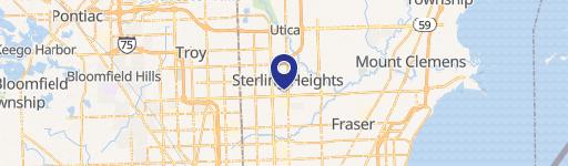
33203 Maple Ln Dr Sterling Heights, MI 48312-6213
Entity Owned
8-yr Hold
~
Est. High Equity
Property ID
US43-0978194
Property profile
Verified
Property type
Specialty properties
Use group
PROFESSIONAL CLUBS/ASSOCIATIONS
Year built
1933
Total area
10,097 SF
Lot
296 ac (12,893,760 SF)
Zoning code
R-80
APN
10-10-34-400-009
UPID
US43-0978194
Cap rate & NOI
Priority signal for investors
Implied cap rate, NOI & suggested price
Cap rate vs submarket · NOI estimate · 3 price anchors
Implied cap rate, NOI & suggested price
Cap vs submarket · NOI estimate · 3 price anchors
Value estimations
Realmo proprietary · 4 methods
AI Approach
AI
by Request
CAP Approach
CAP
by Request
Comparable Approach
Comparable
by Request
Blend (final)
Blend
by Request
Owner & transaction history
City Of Sterling Heights · 8 yrs held
City Of Sterling Heights
since 2017
3 recorded transactions
Zoning & alternative use
R-80 · Sterling Heights, MI
Permitted uses
Permitted uses
Allowed · conditional · prohibited
Zoning description
The one family districts are established to provide an environment suitable for families who typically have children. The districts are principally for one family dwellings at varying densities.
Zone name
One Family Residential
General category
RESIDENTIAL
Zone area
2,488.00 ac
Source
Realmo
Cap rate
Implied · in-place · derived from last sale + estimated NOI
Implied Cap rate
#1
Implied · in-place · NOI ÷ last sale
In-place · derived from last sale + estimated NOI
Cap rate, NOI & submarket benchmark
Implied cap rate vs Sterling Heights submarket · NOI estimate · Typical band, median & reading
Implied cap rate, NOI & submarket benchmark
Cap vs Sterling Heights submarket · NOI estimate · typical band, median & reading
Refine your cap rate
8-question underwriting flow
1.
Property current status — Going-In vs Stabilized
2.
Price for denominator — asking / offer / market
3.
Leasing status & lease structure (NNN / Gross)
4.
Tenant risk profile & vacancy assumption
5.
Upload T12 / rent roll / OM (optional)
Refine in 60 seconds, get exact suggested price
T12 upload · Submarket benchmarks · Sensitivity grid
Suggested price · 3 cap rate anchors
Income approach @ 5% / 7% / 9% — aggressive / typical / conservative
Suggested price at 5% / 7% / 9% cap
Aggressive / typical / conservative · Implied $/SF per anchor · Sensitivity grid
Suggested price at 5% / 7% / 9% cap
Aggressive / typical / conservative · implied $/SF · sensitivity
Value
AI, CAP & Alternative Use estimations · Realmo proprietary blendValue Estimations
Based on Realmo’s proprietary methodology
AI Approach
CAP Approach
Comparable Approach
Alternative Use
Get a detailed, property-specific estimation — fast and free
Price per SF
Sale + rent benchmarks
Subject property
—
Submarket sale & rent benchmarks
Median sale $/SF · Asking & closed rent · Submarket vacancy
Submarket sale & rent benchmarks
Median sale $/SF · asking & closed rent · submarket vacancy
Property tax & assessments
Tax year 2022Property tax & assessments
Tax year 2022
Tax billed
$177,080
Tax year 2022
Assessed value
$4,502,600
Assessed 2023
Previous assessed
$4,400,100
+2.3% YoY
Effective rate
3.93%
On assessed value
Total market value
$9,005,200
Comparables
6 recent transactions · within 1.5 miComparable in this city
6 recent transactions
Comparable in this City


Similar Nearby for Sale


Similar Nearby for Lease


Recent comparable sales
Sale price & price/SF · Sale date & distance · Adjustments & confidence
Recent comparable sales
Sale price & $/SF · sale date & distance · adjustments
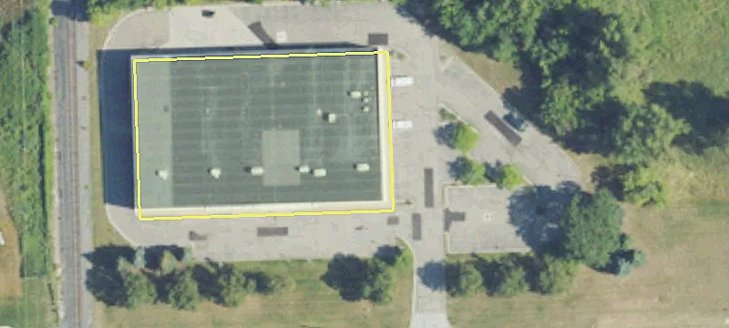
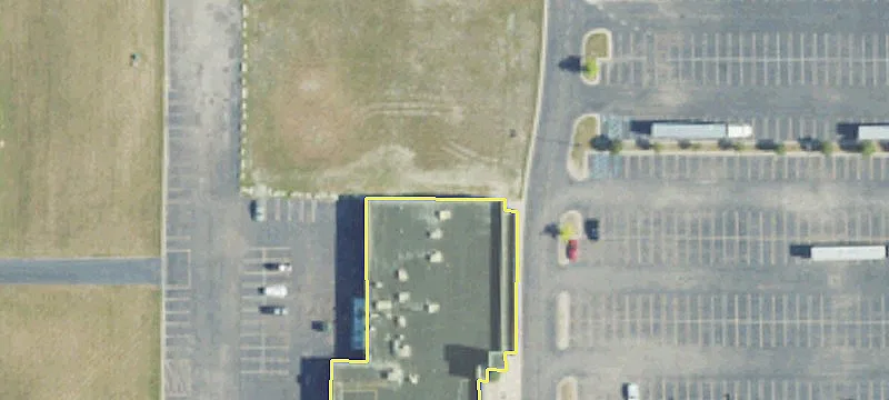
Property description
Physical attributes from public recordsBuilding & lot
Public records
Property type
Specialty properties
Use group
PROFESSIONAL CLUBS/ASSOCIATIONS
Status
Off-Market
Year built
1933
Heating
FORCED AIR
Stories
2
Bathrooms
1
Total area
10,097 SF
Lot
296 ac (12,893,760 SF)
Zoning code
R-80
APN
10-10-34-400-009
UPID
US43-0978194
Jurisdiction
MACOMB
Metro division
WARREN-TROY-FARMINGTON HILLS, MI METROPOLITAN DIVISION
Zoning & alternative use
R-80 · Sterling Heights, MIZoning R-80 · permitted uses
R-80 · Sterling Heights, MI
Permitted & conditional uses
Allowed uses · Special-permit conditions · Prohibited uses
Permitted & conditional uses
Allowed · special-permit conditions · prohibited
Zoning description
The one family districts are established to provide an environment suitable for families who typically have children. The districts are principally for one family dwellings at varying densities.
Zone name
One Family Residential
General category
RESIDENTIAL
Zone area
2,488.00 ac
Source
Realmo
Building & site characteristics
From public records
Year built
1933
Heating
FORCED AIR
Stories
2
Bathrooms
1
Lot
296 ac
Current owner
From public records · entity-resolved
City Of Sterling Heights
Entity
Mailing address
3005 UNIVERSITY DR STE #100, AUBURN HILLS, MI 48326-4609
Ownership since
2017
Owner contacts — direct phone, email, and related entities
Decision-maker phone · Verified email · Related entities & filings
Owner contacts
Email · phone · related entities
Sales History
3 recorded events · public records
Date
Price
Buyer
Seller
Deed Type
Mortgage
Nov 27, 2017
—
City Of Sterling Heights
Maple Lane Holdings LLC
Warranty Deed
—
Aug 14, 2015
—
Maple Lane Holdings LLC
Maple Lane Golf Club
Quit Claim Deed
related
—
—
—
Maple Lane Golf Club
—
Deed Of Trust
related
$325,463 · United Bank & Trust Co
Coming soon
Costs & Benchmarks
Operating expenses, capex projections, utility benchmarks, and submarket comparables — all in one view.
Coming soon
Risks
Flood, climate, environmental, title, and tenant-concentration risk — surfaced with mitigations and source citations.
Try Rey
Ask anything about this address in plain English.
“Is 15.6% cap rate sustainable?” · “Best tenant mix for BU1?” · “What’s the redev upside?”
You own 33203 Maple Ln Dr?
List it free. Reach 20,000 daily buyers.
We’ve already pulled the facts. Confirm photos + price and you’re live in 2 minutes.
List this address →
Full reports are paid
Unlock the full Property Analytics report
Start free for 7 days — no card required. Full owner contacts, all 4 valuations with methodology, refine flow, comparable adjustments, foot-traffic deep dive, export to PDF / CSV.


